
We Killin it!
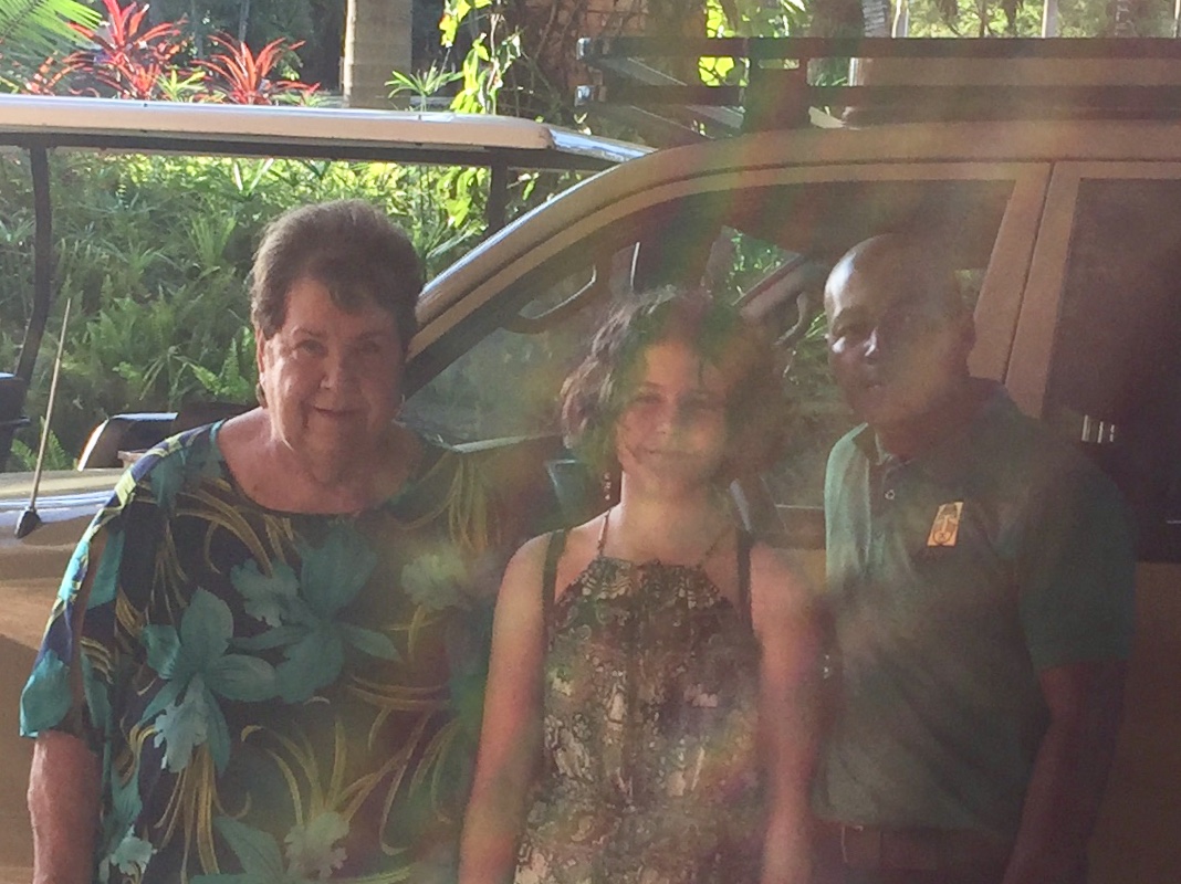
Big game (short) drive: The amazing luxury safari experience for Kate and Ann Wroblewski.
It was a fun filled moment for Kate and her grandmother Ann as they ventured out to explore the magnificent wildlife on a game drive and boat cruise in Murchison Falls National Park.
Big game (short) drive: The amazing luxury safari experience for Kate and Ann Wroblewski.
It was a fun filled moment for Kate and her grandmother Ann as they ventured out to explore the magnificent wildlife on a game drive and boat cruise in Murchison Falls National Park.
We always strive to deliver beyond client expectations thus making us the safari company of choice for would be travelers to the delightful East Africa.

Plenty of Wildlife

Rogers executed the safari once again and yes he did deliver.
Come witness the majesty and abundance of wildlife in Murchison Falls National Park, Uganda’s largest national park, by venturing out on a game drive at sunset and a boat cruise in the afternoon. Murchison Falls National Park lies on the Northern end of the the Albertine rift valley and is engulfed by Savannah Plains which further enhances the chances of spotting wild game during game drives.
“The only man I envy is a man who has not yet been to Africa, for he has so much to look forward to”
Come and travel with us this year to the Pearl of Africa
Contact us now: travel@adyeri.com

Memorable Bucketlist Experiences
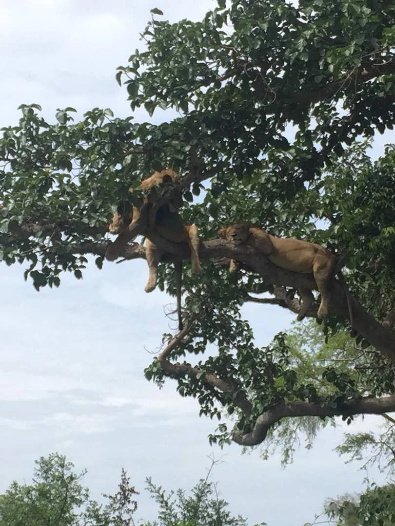
A fantastic capture & rare bucketlist moment for David Cole and his mum on a recent safari with Adyeri Creations @treeclimbinglions. Its not an everyday affair that travelers to Queen Elizabeth National Park get to see a full pride of tree climbing lions up in the trees.
A fantastic capture & rare bucketlist moment for David Cole and his mum on a recent safari with Adyeri Creations @treeclimbinglions. Its not an everyday affair that travelers to Queen Elizabeth National Park get to see a full pride of tree climbing lions up in the trees.

Congratulations to Rogers Muhumuza for yet again executing a successful and memorable safari.

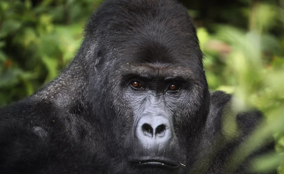
And yes, David and his mum definitely did track and see the Mountain Gorillas in Bwindi National Park.
We know Uganda, drop us an email (travel@adyeri.com) to book your once in a lifetime memorable safari.

Uganda Safari
Popularly known as Masaba by the local people, Mount Elgon is an extinct volcano that last erupted over 24 million years ago. The mountain’s volcanic past is evident in the hot springs that still bubble out of the caldera floor.Some scientists judging from Mount Elgon’s 50 kilometer diameter reckon it may have been higher than Africa’s highest mountain, Kilimanjaro. Elgon’s highest peak Wagagai, reaches 4,321 meters above sea level.
Mount Elgon National Park, Uganda

About
Popularly known as Masaba by the local people, Mount Elgon is an extinct volcano that last erupted over 24 million years ago. The mountain’s volcanic past is evident in the hot springs that still bubble out of the caldera floor.
Some scientists judging from Mount Elgon’s 50 kilometer diameter reckon it may have been higher than Africa’s highest mountain, Kilimanjaro. Elgon’s highest peak Wagagai, reaches 4,321 meters above sea level.
Besides volcanic forces many other geological events have shaped Mount Elgon, the many crate lakes in the mountains caldera were formed by glaciers, which extended from summits down to about 3,500 meters during the Pleistocene era. The same glaciers gouged a deep gash out of the eastern wall, creating what is now the Suam Gorge.
Jutting westwards from the main mountain is the Nkokonjeru peninsula, a 2,350 meter ridge extending for about 20 kilometers. Years of land use practices and a growing population have had their effect on the area, which is one of the reasons the park was created.
Gazzeted on October 1993, the 1,145 square kilometer Mount Elgon National Park is primarily concerned with conserving and restoring the original forest that once covered the slopes, enabling the mountain to continue its essential role as a major watershed.
The area around the park is largely occupied by the Bagisu people, one of the few ethnic groups in Uganda that still practice traditional circumcision. Mainly agriculturalists they grow crops that include coffee, banana’s (locally know as matooke), millet, potatoes, beans and peas.
With the friendly people in the area, waterfalls, caves, hotsprings, mountain vegetation, peaks, the Suam Gorge, and the fascinating caldera itself, Mount Elgon is an exciting place to explore.
Getting there

Mbale, where the mountain park headquarter is located is 250 kilometers from Kampala, 97 kilometers from Soroti, 45 kilometers from Tororo to the south, and 224 kilometers from Moroto to the north. It is served y an excellent tarmac road from Kampala, Tororo and Soroti.
When to go
The best time to visit is during the dry season from June to August and December to February, with the latter preferable. However, even at other times of the year it is manageable although strong rains that cause landslides have been reported in recent times in area.
Where to stay
With the exception of hotels that are located in Mbale Town like Mbale Resort Hotel, there quite a number of lodges at the foothill of the mountain and camping sites on the hiking trails. Some of the lodges at the foothill of Mount Elgon National Park include; Kapkwata Guesthouse, Suam Guest House and the Sasa River Camp.
Sightseeing
It takes about four hours by road from Kampala to Mbale. To get there head east out of the capital on Jinja road which takes you past the Lugogo indoor stadium, through the middle of the KCCA sports grounds and the Kyadondo Rugby Stadium before you pass the Namanve Industrial park on your way out of Kampala.
After 80 kilometers, you come to Uganda’s third largest town, Jinja , the location of the source of the Nile and home to the Owen Falls Dam. From Jinja, stay on the main tarmac road heading east to Tororo, which is 125 kilometers away. On the way you pass some fairly major trading centers and towns like Bugembe and Iganga.
It’s a 45 kilometre drive from Tororo on the main tarmac road to Mbale, where the headquarters of the Mount Elgon National Park is located. Although an attractive town, Mbale itself does not have much of interest. The 30 minute walk from Mount Elgon Hotel to the town center is pleasant.
To reach the Mount Elgon National Park headquarters from the center of Mbale, take the road south east from the clock tower into Masaba road. The office is about one and a half kilometers from town opposite the Mount Elgon Hotel.
Mount Elgon is ideal for climbers seeking a less strenuous alternative to Rwenzori Mountains, as scaling Mount Elgon requires no technical climbing skills, and all major summits are accessible to hikers. The beautifully wooded slopes, smaller scale, and milder climate make Mountain Elgon a wonderful wilderness experience.
There are two main trails in the park: the Sasa and the Piswa, and any combination of the two trails is possible depending on your fitness levels. Ideally you should allow at least five days for a normal trip which includes climbing the highest peak, Wagagai but a seven day trip is more comprehensive also allowing you to visit the Caldera and climb Jackson’s point the second highest peak.

Another memorable safari
A VERY special sighting that our guests, the Eun Kyung family, had recently on a safari they booked with us!
A VERY special sighting that our guests, the Eun Kyung family, had recently on a safari they booked with us!


Book yours today to stand a chance to see amazingly special sightings like this!

Uganda Safari
Gazetted in 1993, Semuliki National Park lies in the Semuliki Valley northwest of Fort Portal. Formerly a forest reserve, the 220 square kilometer park is virtually untouched by development of any sort making it a great place to spend a few days just relaxing and exploring. The park shares its unique ecosystem with the Ituri Forest, across the Semuliki River in the Democratic Republic of Congo.
Semuliki National Park

About
Gazetted in 1993, Semuliki National Park lies in the Semuliki Valley northwest of Fort Portal. Formerly a forest reserve, the 220 square kilometer park is virtually untouched by development of any sort making it a great place to spend a few days just relaxing and exploring. The park shares its unique ecosystem with the Ituri Forest, across the Semuliki River in the Democratic Republic of Congo.
Semuliki is the only park in Uganda primarily made up of tropical lowland forest, which is characterized by more diverse vegetation. Its wetter and the vegetation is more dense with rains for the bigger part of the year. You can experience a good taste of local life by visiting one of the nearby markets.
Getting there
Sempaya, where the road first meets the park boundary is roughly 41 kilometers from Fort Portal and thus 363 kilometers from Kampala. Ntandi where the park headquarters is located is a few kilometers further along the same road.
When to go
Be prepared for wet weather most of the year. If you’re interested in hiking in the area, this is best during the dry seasons from June-July and December –February. No matter when you travel please carry hiking boots.
Where to stay
It’s better to stay in Fort Portal and start off for Semuliki National Park the following morning. In Bundibugyo just south of the park you can access some great accommodation facilities.
Sightseeing
From Fort Portal head north east out of town on Lugard road and then turn left into Saka road opposite the golf course eight kilometers from town you get to Lake Saka, a lovely crater lake. If you continue along Saka road it curves west and eventually joins up with the road that heads towards Bundibugyo.
For Semuliki National Park head west out of Fort Portal town on Bwamba road towards Bundibugyo. After 41 kilometers you will reach the park’s Hot Springs Office at Sempaya where the road first meets the Semuliki National Park boundary. There is a number of hot springs in Sempaya one of which is 26 meters wide with temperatures of about 106 degree Celsius. The water and the surrounding land are rich in salt and sulphur which attracts an unusually large population of shoebirds.

A short nature trail loops around the hot springs at Sempaya. Another more adventurous hike from Sempaya leads along the park boundary north to the Semuliki River and the Democratic Republic of Congo border. The Semuliki River provides another of park’s micro habitats, with vervet monkeys playing along the river banks.
Hiking through the park takes you through a variety of habitats; including clearings of grasslands, bits of swamp. Isolated stands of palm oil, acacia or glimpses of bamboo swamp. Animal you expect to see as you hike include elephants, buffalo, leopard, civet, hippos and crocodiles as well as different species of primates which may include the white colobus monkey, red tailed monkey, baboon and vervet monkey.
The park is also home to some 400 bird species and 300 different species of butterflies

Uganda Safari
At the extreme south western tip of Uganda on the borders with Rwanda and the Democratic Republic of Congo lies Uganda’s smallest national park covering 33.7 square kilometers.The Mgahinga Gorilla National Park established in 1991 is also one of Uganda’s newest national parks. It is an integral part of the Virunga Conservation Area and is contiguous with Parc National Des Volcans in Rwanda and Parc National Des Virunga in the Democratic Republic of Congo (DRC)
Mgahinga Gorilla National Park

About
At the extreme south western tip of Uganda on the borders with Rwanda and the Democratic Republic of Congo lies Uganda’s smallest national park covering 33.7 square kilometers.
The Mgahinga Gorilla National Park established in 1991 is also one of Uganda’s newest national parks. It is an integral part of the Virunga Conservation Area and is contiguous with Parc National Des Volcans in Rwanda and Parc National Des Virunga in the Democratic Republic of Congo (DRC)
Three extinct volcanoes lie within the park: Mount Muhabura, at 4,127 meters; Mount Gahinga at 3,475 meters; and Mount Sanbinyo at 3,645 whose peak lies along Uganda’s border with Rwanda. Mgahinga is afro montane tropical rainforest, and the vegetation is typical of this terrain, with a montane forest belt, a bamboo zone, an ericaceous belt, and an alpine zone. The park is surrounded by the terraced fields of the Batwa and Bafumbira people. The Batwa lived in the forest as hunters and gatherers but have since resorted to farming.
Most of the lower forest in the park has been lost as a result of human pressure over the last five decades. Bamboo and alpine habitat are largely all that remain. The local people benefit from the park with a portion of gorilla permit fees going to local development and conservation.
Getting there
Kisoro where Mgahinga Gorilla National Park is located is 496 kilometers from Kampala, 213 kilometers from Mbarara and 66 kilometers from Kabale.
When to go
As a rainforest the park is always wet even more so during the rainy seasons of April – May and October – November. But as Gorilla permits are hard to come by for only a limited number of people per day, it’s advisable to track the Gorillas when you can. It’s important to note that Gorilla permits are discounted during the months of March-May and September – November with visitors only paying 450 USD as opposed to the 600 USD paid during the peak seasons of June- August and December – February.
Do the Math and compare that with a Rwanda Gorilla Permit that costs 1,500 USD all year round and you will notice that you will be saving a whooping 1,050 USD.
Sightseeing
From Mbarara continue towards Kabale on the main tarmac road to the south west through the towns of Kinoni and Ndejja to Ntungamo, the headquarters of Ntungamo district a 66 kilometer drive from Mbrarara. There the main road heads more directly southern through Rubare, Rushenyi, and Bukinda to Kabale, which 86 kilometers past Ntungamo.
Kabale in southwestern Uganda is the unofficial capital of the Kigezi region and is a beautiful mountainous area with steep sided hilly slopes. It s an area crisscrossed by numerous tracks and paths making it a haven for hikers. One of the most beautiful attractive places is Lake Bunyonyi , which is situated over a ridge to the north west of Kabale Large and irregular Lake Bunyonyi features a number of islands and is surrounded by heavily cultivated hillsides.
From Kabale its about 66 Kilometers by road to Kisoro, the road offers spectacular views of the peaks of the Virunga mountain range. If you feel like exploring in Kisoro while waiting for the Gorilla tracking activities, you can visit lakes Mutanda and Muhele a few kilometers north of the town.
Getting to the Gorillas
Before tracking the Mountain Gorillas you have to make an advance payment for which a Gorilla permit shall be issued by the Uganda Wildlife Authority. The Uganda Wildlife Authority will also give you updated information regarding Gorilla Permit availability and current fees. The gorilla viewing situation is constantly changing so we avail you with updated information prior to travelling.
Gorilla Tracking permits cost 600 USD for Foreign Non-Residents and 400 USD for Foreign East African Residents (You qualify to be an East African Resident if you reside in Uganda, Kenya, Rwandaand Tanzania)
On the day you intend to track the Gorillas you have to be at the Park headquarters at Ntebekko Camp at the mountain foothill by 0830. Once there be prepared for some strenuous walking and scrambling through thick undergrowth. You must be in good physical shape. To protect the Gorillas from disease, children under the age of 15 and people who are ill are prohibited from entering the park. Keep in mind that Gorillas are primates and there DNA is closely linked by 97% with that of humans; so they can contract disease from humans like flu that’s why it’s advisable to stay clear when you’re ill. Follow you tour guide’s instructions because these animals are wild and capable of killing people. There are less than 800 mountain gorillas in the world of which almost half live in the Virunga conservation area and the other half in Uganda’s Bwindi Impenetrable National Park, about 25 kilometers north of Mgahinga. If you’re taking photographs remember not to use the flash feature on your camera because the Gorillas are dark and their habitat is dark. Carry along a specialized camera or smart phone that won’t necessitate using flash.
Besides Mountain Gorilla Tracking, other activities on offer at the Mgahinga National Park include tracking the Golden Monkey and the park also supports uniquely adapted animals and plants. More than 185 bird species have been recorded in the area.
There are also a number of exciting hiking options to take while at the park which showcase Mgahinga’s dramatic views, lush vegetation and wildlife. Visitors may for instance attempt the full day challenging climbs to the tops of Mount Muhabura and Mount Gahinga, who summits offer great view of Uganda, Rwanda and the Democratic Republic of Congo. You’re bound to see lots of unique alpine vegetation and a small volcanic lake hidden away at the top of Mount Muhabura. For safety reasons climbing the nearby Mount Sabinyo is not recommended but you can hike through the beautiful and dramatic Sabinyon Gorge.
Another outing can be arranged at the Garama Cave, where humans once sheltered during the late Iron Age. The cave rumoured to cut through to Rwanda is about two kilometers from Ntebeko Camp. The visit last two to three hours and does not require any special hiking skills.
Mgahinga Gorilla National Park also features a 13 kilometer nature trail, providing the opportunity to learn about the ecology and wildlife of this park. During the walk you might see the Golden Monkeys, Duikers and Bushbucks. For trekking to see the gorillas or going on any of the organized hikes, good hiking boots or gumboots (Wellingtons), good rainwear and warm clothing are recommended.

Memorable Safari Experiences
Every week we select the best images from our Guests & Guides - have a look at some of our favorites!

At Adyeri Creations we combine affordability with comfort and deliver the perfect safari experience in the delightful Pearl of Africa.
New Year, great safaris; We strive to deliver memorable Gorilla Tracking and Wildlife Safari experiences.
Be enchanted by these images, taken on a recent trip with, Cara Picton and our guide Tom. We thank Tom for a job well done.


The Scenic Nkuringo Gorilla Camp @ Bwindi Impenetrable National Park
Bwindi’ second Gorilla tracking trailhead, which opened in 2004 after habituation of the group that started in 1996, lies at an altitude of 2,100m on the park’s southwestern border north of Kisoro. The surrounding hills are densely settled by farmers. It is a very scenic area, set along the Nteko Ridge, which provides grandstand views across the Kashasha River Valley into Bwindi Impenetrable National Park and the forest which cloaks the valley’s northern slopes. Nkuringo means ‘round stone’ and refers to knoll-like forested hill that’s set beside the river, but is dwarfed by loftier ridges above it. To the south and west superb panoramas include the entire length of the Virunga volcanic range. The International Gorilla Conservation Programme has purchased 10km-long by 400m-wide strip of public land along the river as a buffer zone for the growth of crops that are not appealing to Gorillas.
BWINDI IMPENETRABLE NATIONAL PARK
Uganda’s most important tourist hotspot is the 331km2 Bwindi Impenetrable National Park which protects a rugged landscape of steep hills and valleys abutting the Congolese border south of Ishasha and north of Kisoro. Rolling eastward from the Albertine Rift Escarpment, the tangled forested slopes of Bwindi provide shelter to one of Africa’s most diverse mammalian faunas including 45% of the global mountain gorilla population. Unsurprisingly, the main tourist activity in Bwindi Impenetrable National Park is gorilla tracking, which was first established at the Buhoma park headquarters in 1993, but now operates out of four trailheads –the others being Nkuringo, Ruhija and Rushaga – all of which are served by a selection of tourist lodges. Today 11 habituated Gorilla groups can be tracked in Bwindi. Bwindi Impenetrable National Park is also one of the finest birding destinations in Uganda, while other attractions include forest walks in search of smaller primates such as golden monkeys, black and white colobus and L’Hoest’s monkey.

NKURINGO GORILLA CAMP
Bwindi’ second Gorilla tracking trailhead, which opened in 2004 after habituation of the group that started in 1996, lies at an altitude of 2,100m on the park’s southwestern border north of Kisoro. The surrounding hills are densely settled by farmers. It is a very scenic area, set along the Nteko Ridge, which provides grandstand views across the Kashasha River Valley into Bwindi Impenetrable National Park and the forest which cloaks the valley’s northern slopes. Nkuringo means ‘round stone’ and refers to knoll-like forested hill that’s set beside the river, but is dwarfed by loftier ridges above it. To the south and west superb panoramas include the entire length of the Virunga volcanic range. The International Gorilla Conservation Programme has purchased 10km-long by 400m-wide strip of public land along the river as a buffer zone for the growth of crops that are not appealing to Gorillas.
What to do and see
Gorilla tracking
One habituated group of Gorillas can be tracked at Nkuringo. It was comprised of 21 individuals, but the two dominant silverbacks went their own ways in 2014, so the original Nkuringo Group now consists of 12individuals including three silverbacks, while the splinter Bushaho Group contains nine individuals and just one silverback. The latter was being habituated at the time of research and should open to tourism towards the end of 2016.

Buinga Community Forest
Meet the Batwa, then and now the, the 3 km 2patch of the regenerating forest on the outskirts of Nkuringo village is owned by the local Batwa community and inhabited by a variety of monkeys and birds. A 2-3 hours guided trail through the forest gives you the chance to see the Batwa and is usually followed followed by a visit to the contemporary settlement of Snuriia, where 150 of the former hunters-gatherers have been resettled about 4 km from Nkuringo. Batwa guides demonstrate aspects of their traditional forest life-creating shelter, firing bows and arrows, making fire, identifying medicinal herbs. The enjoyable and informative guided walks can be arranged trough Nkuringo gorilla camp.

Nkuringo Community Walk
This community activity provides insights into Bakiga life and culture, with visit to a traditional healer, black smith, brewer and homestead in the vicinity of Nkuringo village.
Hiking
Nature walks into the national park can be arranged, but the steep nature of descent (and ascent) makes it a less appealing project that than at the other trailheads. Nkuringo is a superbly scenic area with great potential for hiking outside the forest, through the possibilities for haphazard exploration are pretty limited. The steep nature of Nteko ridge means the main alternatives for a pleasant stroll are either west along the ridge-top road towards DRC or east towards Rubugeri.
Walking Safari Activity
Guided nature walks between buhoma in the Bwindi Impenetrable Forest and Canoe excursions on Lake Mutanda on wards to the town of Kisoro via Nkuringo and vice versa. the experience offers a low cost insider's perspective into the village life in rural Uganda and we will highlight to you some of the wonders of Bwindi Impenetrable Forest all at your own pace.
Accommodation
Luxury; Clouds Mountain Gorilla Lodge
Midrange; Nkuringo Gorilla Camp
Budget; Bwindi Packers Lodge

Uganda Safari
Gazetted in 1982, this park not only encompasses Lake Mburo but also four other smaller parks. It’s easy accessibility from Kampala makes it a favorite destination for short trips. Mainly Savannah with scattered acacia trees, the park features rolling hills, open grass valleys, thickets, woodlands, and rich wetlands. It is home to a wide variety of wildlife and bird life; it is also outstanding in that it has a strong community extension component, trying to work closely with the local people to conserve the wildlife and other natural resources both inside and outside the park.
Lake Mburo National Park

About
Gazetted in 1982, this park not only encompasses Lake Mburo but also four other smaller parks. It’s easy accessibility from Kampala makes it a favorite destination for short trips. Mainly Savannah with scattered acacia trees, the park features rolling hills, open grass valleys, thickets, woodlands, and rich wetlands. It is home to a wide variety of wildlife and bird life; it is also outstanding in that it has a strong community extension component, trying to work closely with the local people to conserve the wildlife and other natural resources both inside and outside the park.
Getting there
The main turn off to Lake Mburo National Park’s Nshara gate is approximately 110 kilometers from Masaka, 219 kilometers from Kampala and 35 kilometers from Mbarara. Its served by the Kampala –Kabale tarmac road although there is a 24 kilometer dirt road to the park gate.
When to go
The park is enjoyable at any time of the year but is particularly green and fresh just after the April-May and October-November rains.
Where to stay
Ranging from Rwakobo Rock, Mihingo Lodge to Mburo Safari Lodge, there ample accommodation facilities that are ideal for a memorable safari experience.
Sightseeing
Head south west on the main road from Masaka, where 77 kilometers further on, you’ll come to the town of Lyantonde. If you are interested in African history and archaeology, you may at this point want to divert from the route to Lake Mburo Park. Turn right on the dirt road from Lyantonde that leads to the town of Ntusi, 61 kilometers off the main road. Although a modern village, Ntusi lies on the site of what is thought to be the most ancient large settlement in Uganda. Strong eveidence suggests that the people of once lived there gave rise to the legendary and mysterious Batembuzi gods, who play a central role in Ugandan folklore.

Legend has it that the first empire in what is now western Uganda was that of the Batembuzi. Oral history places the Batembuzi empire at between 1100AD and 1350AD, and evidence in the Ntusi region confirms that a highly centralized society existed there as early as the 11th century. There are interesting displays regarding the Ntusi region at the Uganda museum in Kampala.
The ancient town is thought to have been the largest settlement in Sub-Saharan Africa when it reached its pinnacle in the 12th and 13th centuries. Its believed to have been the capital of an ancient empire stretching all the way to Lake Albert in the north and thought by some to be the source of the Batembuzi legends. Evidence of iron smelting, wood carvings and ivory have been found there by archaeologists.
From Lyantonde on the main Masaka-Kabale road, continue to head south west. In just 13 kilometers at the 50 kilometer marker you will see a signpost for the first turnoff to Lake Mburo National Park’s Nshara gate. There is a second turn off leading to the Sanga gate, 15 kilometers further along the main road at the Sanga trading center. It is a 21 kilometer drive from Sanga Trding center to the park headquarters.
The east side of park features undulating, low hills broken by rocky outcrops, while in the west a series of rugged hills overlook flat bottomed, open valleys. The grassy valleys offer the best game viewing opportunities, with Impalas being the most remarkable species there, as its found no where eels in Uganda. Herds of Buffalo, Zebra and Eland can also be found, particularly by the waterholes during the drier seasons. Oribi and Topi seen in pairs and small groups are abundant. You’ll also spot families of comical warthogs and occasionally reedbuck which hide in the grass.
The acacia and olive woodland harbor shy bush duikers, as well as waterbuck, vervet monkeys and baboons. Keep an eye out for the elusive Klipspringers and rock hyrax on the granite outcrops in the west of the park and in the rocky hills in east.
The five lakes in the park and several other that lie just outside the southern park boundary are home to crocodiles and hippos which can be seen grazing out of the water on cool mornings. The surrounding papyrus swamps hide the beautiful Sitatunga, which has narrow elongated hooves that allow it to ove easily over marshy, unstable grounds.
Predators are rarely seen in the park, which is why it’s possible to walk anywhere within the park borders provided you are accompanied by a ranger. Either full or half day walking safaris, a wonderful African experience can be arranged.
Bird enthusiasts will delight in this park which offers a variety of water and dry land species, including the rare Shoebill Stork, the Abyssinian ground hornbill, and the sadddlebill stork. The forested area of the park are home to the Narina trogon.
As well as walking safaris and the traditional game drives, the park also offers a self guided nature trail and an interpretation center if you wish to learn more about the park, its wildlife and its ecosystem.
For a first hand view of Lake Mburo we suggest going on a two hour boat trip which is perfect for searching out birds, such as kingfishers and herons, at the water’s edge, watching animals come down to drink water and getting an eyeball to eyeball look at the hippos and crocodiles keep in mind that our tour guide will ensure that you keep a safe distance.

Toro-Semiliki Wildlife Reserve in Uganda
The Semliki valley is set at the base of the Albertine Rift west of Fort Portal, the spectacular valley is hemmed in by Lake Albert to the north and by the Semliki River along the Congolese border, while the Rwenzori foothills protrude into it from the south to create two geographically discrete and ecologically divergent sectors. Northwest of the Rwenzori, the Toro-Semliki Wildlife Reserve protects a tract of moist woodlands running towards the marshy southern shores of Lake Albert. The National Park, whose affinities with the contagious Congolese rainforest are reflected by the presence of dozens of birds and other creatures found nowhere else in Uganda.
THE SEMLIKI WILDLIFE RESERVE

The Semliki valley is set at the base of the Albertine Rift west of Fort Portal, the spectacular valley is hemmed in by Lake Albert to the north and by the Semliki River along the Congolese border, while the Rwenzori foothills protrude into it from the south to create two geographically discrete and ecologically divergent sectors. Northwest of the Rwenzori, the Toro-Semliki Wildlife Reserve protects a tract of moist woodlands running towards the marshy southern shores of Lake Albert. The National Park, whose affinities with the contagious Congolese rainforest are reflected by the presence of dozens of birds and other creatures found nowhere else in Uganda.
The dominant vegetation of Toro-Semliki is open Acacia woodland and grassy savannah, interspersed with patched of borassus palm forest, significant belts of riparian woodlands along the main watercourses and extensive swamps towards Lake Albert. More than 10,000 Uganda Kob are residents together with large herds of Jackson’s hartebeest, Defassa waterbuck, elephants and buffalo .The area is famous for massive manned lions that live there, leopards are also numerous.
What to do and see:
Game drive
Game drives are more or less limited to the main road between Karugutu and Ntoroko, which runs through the reserve for most of its length. Game viewing along this road is rather hit and miss, but taken slowly it can be quite rewarding especially if the visitor has an interest in birds.
Small herds of Uganda Kob and waterbuck inhabit the grassy plains, along with shyer pairs of common reedbuck and family parties of warthog.
Elephants, buffalo and giant hog are also around, but are on an everyday basis and they tend to be rather skittish when approached by a vehicle. Leopards and even lions are very occasionally seen, mostly usually on night drives. The open grasslands host Abyssinian ground hornbill and a variety of raptors, while areas of vegetation are good for marsh and African cake. The Mugiri River Forest is regarded to be the best site in Uganda for exclusive leaf-love and it is also hosts a variety of other localized forest species.

Sempaya Hot Spring
The most popular attraction in Semliki is the cluster of hot spring at Sempaya, Ringed by forest and palm trees and veiled in a cloud of steam, these are primeval, and the largest geyser spouts up to 2m into the air from an opening in a low salt sculpture. The emerging water has a temperature of more than 100oC. The trail to the spring leads through a patch of forest where Red-tailed monkey, grey-cheeked mangabey and black and white colobus are common. Among the more interesting birds regularly seen here are various forest hornbills, breasted king fisher, red-rumped and yellow throated tinkerbird, Frasier’s ant-thrush and honey guided greenbul.

Red Monkey Trail
Following the eastern margin of the national park to the Semliki River, this wilderness trail takes at least 4 hours in either direction, but offers exposure to far greater variety of localized birds than trail to the springs. It can be undertaken as a day trip. In addition to birds, the visitor can expect to see a variety of monkeys, hippos and crocodiles on the river and possibly even buffalo and elephants.


Boat trips
Boat trips on scenic Lake Albert are a highlight of any visit to the wildlife reserve, for bird watchers, this is one of the most reliable sites in Uganda to see Shoebill.
A profusion of more common water birds are also present and the dazzling red-throated bee-eater, forms a large breeding colony on sand banks near Ntoroko .
Walks
One can walk freely in the immediate vicinity of Ntoroko, where the shallows are teeming with bird life. Guided nature walks out of Ntoroko Bandas and campsite.
Accommodation
· Semliki Safari Lodge
· Ntoroko Game Lodge

Rwenzori Mountain National Park
Rwenzori Mountains are protected in a 996km2 that runs along the Congolese border between Semliki valley and Queen Elizabeth National Park. The ranger’s upper slope constitute an aptly lunar landscape of bare black roots and tussock moorland studied with surreal giant lobelias and groundsels, while the lower contours are swathed in a tangled jungle inhabited by shy forest elephants and chimpanzees. Above all this, towering to a maximum altitude of 5,109m, a series of craggy black peaks is coated in permanent equatorial snow and ice.
Rwenzori Mountain National Park

Rwenzori Mountains are protected in a 996km2 acreage of land that runs along the Congolese border between Semuliki valley and Queen Elizabeth National Park. The ranger’s upper slope constitute an aptly lunar landscape of bare black roots and tussock moorland studied with surreal giant lobelias and groundsels, while the lower contours are swathed in a tangled jungle inhabited by shy forest elephants and chimpanzees. Above all this, towering to a maximum altitude of 5,109m, a series of craggy black peaks is coated in permanent equatorial snow and ice.
Flora and fauna of Rwenzori mountain national park
It is a lofty east African mountain the vegetation of Rwenzori can be divided into several altitude zones, each with its own distinct micro climate, flora and fauna. The afro-montane forest zone, which starts at 1,800m, has the most varied fauna. The fauna of the Rwenzori includes 70 mammal and 177 bird species, several of the latter being Albertine Rift endemics. It is also the only national park in Uganda where Angola colobus has been recorded, though identification of this localized monkey requires careful as the similar and more spread black and white colobus also occurs on the mountain.
Hiking and walking routes
The central circuit
For many years this circuit out of Nyakalengija provided the only access to the upper Rwenzori
Day one:
Nyakalengija (around 1,615m) to Nyabitaba hut (around 2,651), 5 hrs; altitude gain 1,036m) from Nyakaengija, it’s a 10km ascent to Nyakitoba hut, passing first through forest there cultivations then through forest there is also piped water supply at the hut.
Day two:
Nyabitaba hut (2651m) to John Matte hut (3,505m). 7hrs; altitude gain: around 854m, this is the longest and most strenuous day’s walk. From Nyabitaba hut the path descends through the forest for a short time before it crosses the Bujuku River at the Kurt Schafer Bridge which was built in 1989.

Day three:
John Matte hut (3505m) to Bujuku hut (3962m), 5hrs; altitude gain 457m, this stage takes up to 5 hours depending on the condition of the bigo bigo, which are often knee deep in mud through a boardwalk has now been constructed across part of it. On the way Lake Bujuku has a magnificent setting between Mt. Stanley, Speke and Baker.
Day four:
Bujuku hut (3962m) to Kitandara hut (4,023m), 3-4 hours; altitude gain 61m , from Bukuju hut you will ascend to Scott Elliot pass (4372m) which is the highest point on the central circuit trail, before descending to the two kitandara lakes. The hut is next to the second lake.
Day five:
Kitandara hut (4,023m) to guy Yeo man hut(3,505m), 5hrs descent 518m, the stage starts with a steep ascent of fresh field pass (4,282) then a descent to Bujongolo cave (3,702m).
Day six:
Guy Yeoman hut (3,505) to Nyakalengija (5 hours 1890m) a 5hrs descent from Guy Yeoman hut to Nyabitaba hut (a descent of 851m).
Six dayshike to Mount Higi di Savoia
Is a six day loop trail summitting the 4,620m Weisman’s peak and 4,627m Stella peak on Mt. Luigi di Savoia. A longer variation on this nine days loop trail incorporating a summit of Mt Stanley’s (5,109m) Margherita peak.
Day one:
Kyamboyho trailhead (1,450m) to Sine hut (2,590m). standing at the main trailhead 2km past Rwenzori back packers, the route runs along the side of the Nyamwamba River Valley for 3km before entering the park along, steady climbing through montane forest.
Day two:
Sine (2,590m) to Mutinda (3,810m), altitude gain 644m. After a stiff climb through bamboo to Kalaana camp, the route flows the Kamusoni River valley up to Mutinda.
Day three:
Mutinda (3810m) to Bugata camp (4,060m) altitude gain 250m, from Mutinda, the landscape becomes bleaker and more dramatic as the trail traverses open moorland between the Kamusomi and Nyamugasani valley.
Day four:
Climb Duke Luigi di Savoia (4,627m) and return to Bugata camp 5-6 hours altitude gain and loss 567m.
Day five:
Bugata camp (4060m) to Kiharu camp (3520m) altitude loss 542m, this lovely hike backwards towards Kilembe follows a different route through a valley to an area of evergreen forest where tree hyrax can be heard at night, monkeys and Rwenzori turacos call by day.
Day six:
Kiharu camp (3,520m) to Kyambogho trailhead (1,450m) altitude loss 2070m, the trail descends along ridge through bamboo and montane forest to the hostel at kilembe.

Kyambura Gorge Lodge @ Queen Elizabeth National Park
On the floor of the great African western Rift Valley, the Kyambura river flowing into the valley over millions of years has carved a deep gorge between the valley walls and the Kazinga channel. An underground riverine forest here is home to a wide range of wildlife including chimpanzees. A nature walk into the gorge is an experience of dramatic change from the savanna grassland to lush forest.
KYAMBURA GORGE LODGE

The lodge is about 1km north of Kichwamba trading center, the architecturally innovative lodge consists of a main building converted from abandoned coffee shed and half-dozen spacious cottages whose eclectic African décor s influenced by local building styles, your besides table might be a ramshackle stand created from a converted old cable drum.
On the floor of the great African western Rift Valley, the Kyambura river flowing into the valley over millions of years has carved a deep gorge between the valley walls and the Kazinga channel. An underground riverine forest here is home to a wide range of wildlife including chimpanzees. A nature walk into the gorge is an experience of dramatic change from the savanna grassland to lush forest.
The stunning kyambura gorge is also called the valley of Apes, this gorge is actually drained by River Kyambura. The landscape is among the most impressive you will find in Uganda and its rich bio-diversity that comprises of primates, birds and wild animals.
The stylish bandas also have a contemporary theme with the accent on the local art facts re imagined in a new context. Each banda offers a unique view either across the gorge or the savanna.
What to see at the lodge
Chimpanzee Tracking:
Some of the chimpanzees in the gorge have been habituated, and the process took 2 years meaning that these chimpanzees are familiar with humans and can carry on their day to day activities in the presence of humans

Bird Watching:
Characterized by wooded savannah, the Kyambura gorge in the west and the Kazinga channel in the north. Some of the birds at Gorge are marabou stock, saddle billed stock, shoebill stock, African skimmer, sarced Ibis, red necked francolin, gulls, terns, white browed coucal and many more.

Guided Nature and Forest walks:
Three different guided walks can be undertaken from the visitors, the most straightforward trail loops around the forest shore of Lake Kyasanduka for dedicated bird watchers the second rewarding walk is likely to be at Lake Nyamasigiri, which comprises of five interlocking crater lakes and extends over 4km2. The third hike leads to a large cave that host large colony of bats, as a well as a few rock pythons that feed on them.
Access to the Kyambura Gorge:
An isolated strip of riparian forest in the 100m deep Kyambura river gorge, which runs 16km on the park’s eastern boundary with Kyambura wildlife reserve, the confined nature of the forested gorge makes it quiet easy to locate chimps by sound.

Facilities
International and local cuisine
Swimming pool
Communal lodge area
Cosy sofa area
Large bed with walk in net and self-contained bathrooms
Villagers sing in the nights and mosque calls provide an early morning wake up

Ishasha Wilderness Camp @ Queen Elizabeth National Park
Arguably the only true wilderness facility in Uganda and the only lodge actually set with in the park’s Ishasha sector, the excellent camp is carved into the riparian forest along the Ntungwe River and located in the thick of the wildlife action.
ISHASHA WILDERNESS CAMP

Arguably the only true wilderness facility in Uganda and the only lodge actually set with in the park’s Ishasha sector, the excellent camp is carved into the riparian forest along the Ntungwe River and located in the thick of the wildlife action. Elephants regularly cross the river within view of the camp, lion and leopard are often found close by, while colobus monkeys emit their guttural croak in the trees overhead. This place is alive with birds, including the Pel’s fishing owl and African finfoot.
Spacious, Wooden Framed, Canvas Tented Rooms
Set next to the Ntungwe River, each of the camp’s ten spacious canvas tented rooms has a private verandah overlooking the river. Comfortably furnished with large mosquito-netted beds, all rooms are en suite with hot ‘bush’ showers, running water for hand-basins and a flushing ‘eco-friendly’ toilet.

Restaurant and Bar
The thatched central lounge and dining area provide a comfortable setting for meals and relaxation, although we often serve meals ‘al fresco’ next to the river. In the evening, the outdoor fireplace is the perfect place for guests to relax with sundowners and share their day’s experiences.

Meals are freshly prepared with many local ingredients, offering a balance of international and locally flavored cuisine with all meals being of several delicious courses. Our bar has a selection of local and imported beverages and our friendly local staff will attend to your needs.
Hot beverages are available throughout the day on a self-service basis, and are delivered to your room with early morning wake up calls as required, allowing you to savour the early morning sounds of the ‘bush’ awakening.
Other Services
Being within the park you may be lucky enough to see wildlife moving freely through the camp. Our attentive security staff is always on hand to escort and assist you should you feel the wildlife is too close.
Bush breakfasts and sundowners within the wilderness of the National Park complete the ‘bush’ experience offered at Ishasha Wilderness Camp.
Free Wi-Fi internet, recharging facilities and a curio/local craft shop are available in the central dining area.
Activities
Sundowners and Bush Breakfasts
Safaris in the Ishasha sector of the Park
Community Tours and Visits
Hot Air Ballooning
Chimpanzee Trekking In Kyambura Gorge
Cruise the Kazinga Channel
Ishasha tree climbing lions
Birding and Wildlife Walks

Mweya Safari Lodge @ Queen Elizabeth National Park
Mweya safari lodge is located on the peninsula in the heart of Queen Elizabeth national park it is almost compete surrounded by water with a join dropping view of the kazinga channel, the channel that connects Lake George to Lake Edward.
MWEYA SAFARI LODGE

Mweya safari lodge is located on the peninsula in the heart of Queen Elizabeth national park it is almost compete surrounded by water with a join dropping view of the kazinga channel, the channel that connects Lake George to Lake Edward.
The rooms at Mweya Safari Lodge have a bit of reputation it is rumored that they were built strategically so the guests can get a view of all sorts of wildlife in the comfort of their rooms. Mweya Safari lodge has 8 categories of rooms namely; Standard room, deluxe room, deluxe tent, twin tent room, suite, Rwenzori cottage, Queen Cottage, presidential cottage.

The Queens cottage is a luxurious cottage with large living room and dining room a 41 inch TV set with Dstv and 5.1 sound system, the cottage luxurious master be room with king size bed an en-suite bathroom with a bath tab also in the cottage there is twin bedroom with en-suite bath room with big balcony with spectacular view of the vegetation, wildlife and the kazinga channel.
There is also the Mweya state of art health club with an exercise studio, sauna steam bath, hair salon and massage facility.
Facilities and Services
Stunning views greet you through large windows in the lodge's foyer, where you receive a very warm welcome.
Swimming Pool
Restaurant and Cuisine
Business Centre
The Gift Shop
Conference Facilities
Mweya Information Centre
The Tembo Bar
Activities at Mweya Safari Lodge
Birding:
Some 610 bird species have been recorded at the park, a remarkable figure for what is relatively small national park by the standards. In addition to 54 raptors, the checklist includes virtually every latter largely confined to the Maramagambo forest birds like common bulbul, rattling cisticola, d’arnaud’s barbet, African grey woodpecker, African palm swift, pearl spotted owlet and many more.
Safari Drive:
The two main game circuits run out of Ishasha the northern and southern loops, both roughly 20 km in length. The southern circuit is the more productive for lion sighting since it passes through the main Kob breeding grounds- as in Kasenyi, the predators often stick close to their prey. The northern circuit is favorable for birding.
Water Safari:
Water safari at Mweya can be done a boat called a Hippo, on a Hippo visitors are able to see elephants, buffalos and hippos depending on the weather.

Chimpanzee Trekking:
The only habituated chimpanzee community in Queen Elizabeth National Park inhabits an isolated strip of riparian forest in the 100m-deep Kyambura River Gorge, which runs for 16km on the park’s eastern boundary with the Kyambura wildlife reserve. The confined nature of the forested gorge makes it easy to locate the chimps by sound.
Katwe Explosion Craters:
The lake is separated from the northern shore of Lake Edward, the 2.5km2 hyper-saline lake occupies the base of a volcanic caldera that last erupted between 5,000 and 10,000 years ago. It is one of the oldest and most productive sources of salt in Uganda.

Tree Climbing Lions:
The activities of several climbing lions pride living to the north of the Kazinga channel. These tree dwelling lions feed on the Uganda Kob and Cape buffalo
Bush Breakfast:
Guests are driven to a beautiful picnic spot via the channel track and campsites along the way guests are able to see wild animals like warthogs, leopard and bird watching.
Pelican point:
The point offers excellent views across Lake Edward and you’ll appreciate why it was proposed as the park’s first lodge in the 1950s, but Mweya was selected owing to its more central location.
Hot Air Ballooning:
Mweya safari lodge teamed up with balloon a safari which now runs daily flights over the Kasenyi plains, subject to weather conditions and demand. The balloon offers a chance to see Giraffes and other wildlife from close to the ground, as well as going up high for views of the lanes, channel and Rwenzori peaks.

Nkuringo Gorilla Campsite @ Bwindi Impenetrable National Park
The old Nkuringo community campground is unrecognizable in its new private run incarnation as a borderline upmarket lodge whose rooms have generous dimensions, vibrant décor and the homely atmosphere, the lodge remains the most stunning site with views north across Bwindi towards Buhoma village, Lake Edward and the Rwenzori, & the Virungas to the south.
NKURINGO GORILLA CAMPSITE
Nkuringo Gorilla Campsite is just a few kilometers before Kisoro town council. The magnificent safari lodge is spotted in the hazy hills. By design established on the shores of Lake Mutanda adjust to the Mushengero peninsular overlooking the prominent Virunga Volcanoes .The position of the lodge gives a chance to view the Nkuringo family of gorillas along with the Mgahinga Gorilla groups around the Camp.
The old Nkuringo community campground is unrecognizable in its new private run incarnation as a borderline upmarket lodge whose rooms have generous dimensions, vibrant décor and the homely atmosphere, the lodge remains the most stunning site with views north across Bwindi towards Buhoma village, Lake Edward and the Rwenzori, & the Virungas to the south.

The most exciting aspect about this camp is the Bafumbira with their local brew that tastes so sweet. They dress according to their culture and most of them have smoking pipes, this is just to keep them warm because of the changing weather. They are always carrying their luggage with a long stick for protection.
Accommodation
There accommodation is excellent with self-contained tented rooms along with cottages.
Bar and Restaurant
The safari lodge is well known for its fully stocked bar along with a restaurant that serves both international and local cuisine.
Tourism Activities at Nkuringo
The major activity is tracking the Nkuringo Gorilla family:
Nkuringo is the most physically challenging of all Gorilla-tracking locations. Unlike the existing tracking sites at Buhoma and Mgahinga, there is no vehicle access from the Nteko Ridge to the park boundary which follows the Kashasha River. The original Nkuringo group now consists of 12 individuals including three silverbacks.

Guided nature walks:
The community walk activity provides insights into the Bakiga life and culture, with visits to a traditional healer, blacksmith, brewer and homestead in the vicinity of the Nkuringo village
Visit the Pygmies (Batwa Community):
The Batwa (singular Mutwa) are a pygmies people easily distinguished from the other Ugandans by their short stature – an adult male seldom is around 1.5 m in height and paler more bronzed complexion. The tradition of the Batwa lifestyle is based around hunting, which is undertaken as a team effort by the male members of the community, usually using nets and poisoned arrows. Batwa men also gather wild honey, while women gather edible plants to supplement the meat.

Bird watching

Silverback Lodge @ Bwindi Impenetrable National Park
The lodge has sweeping views of Bwindi Impenetrable National Park - a 124-square-mile site home to approximately 350 mountain gorillas (half of the world's remaining population), non-habituated chimpanzees, more than 100 other species of mammals, 346 species of birds, 200 butterfly specie, 50 Amphibians and Reptiles and 163 species of trees
SILVERBACK LODGE

Silverback Lodge is located in the Buhoma sector of Bwindi Impenetrable Forest National Park in western Uganda, Silverback Lodge is only a 5 minute walk to the national park and has sweeping views of the valley and forests that surround it. The lodge is 478 km around 8 hours 30 minutes drive from Kampala.
The lodge has sweeping views of Bwindi Impenetrable National Park - a 124-square-mile site home to approximately 350 mountain gorillas (half of the world's remaining population), non-habituated chimpanzees, more than 100 other species of mammals, 346 species of birds, 200 butterfly specie, 50 Amphibians and Reptiles and 163 species of trees
The lodge
Silverback Lodge is perched on high, a top the valley overlooking Bwindi Impenetrable National Park. The view is absolutely stunning and the best place to enjoy Apes-tracking cocktails. Bird watching and sometimes primate viewing is possible right from the front door of your room. With 12 rooms, we are the largest lodge in the area and will remain one of the best value properties in the region, whilst keeping the Marasa Africa standards of comfort and hospitality.

The tilled rooms, big enough, have modern feel, with nets, en-suite hot shower and private balcony the beat deal for comfort- conscious visitors.
Silverback Lodge is perched high above the valley overlooking beautiful flora and fauna. From the Summit Bar you can enjoy après-trekking cocktails with friends and family. Bird watching and primate viewing are possible right from the front door of your room.
The lodge has beautiful gardens, perfect for relaxing and enjoying the magnificent landscape of the Bwindi forest after a long day’s hike.
What to do and see at the Lodge
Gorilla trekking:
Tracking the Gorilla in Bwindi ranks among the absolute highlights in Africa travel. The exhilaration attached to first setting eyes on a wild mountain Gorilla is difficult to describe. These enormous animals, up to three times as bulky as the average man and their size exaggerated by a shaggily luxuriant coat.
Bird watching:
Bwindi impenetrable forest holds over 346 species of birds and contains 90% of all the Albertine Rift endemics, difficult or impossible to see in any part of East Africa. For the ornithologist, close to 100 bird species can be identified in a day birds like Abdim’s stork, Sacred Ibis, Spur-Winged Plover, African Jacana, Eurasian Roller, Woodland Kingfisher, Cape Rook, African Paradise Flycatcher, Red-billed Oxpecker and many more


Hiking:
Nature walks into the national park can arranged at the lodge, the steep nature of the descent and ascent makes it a less appealing prospect than at the other trailheads.
Day and night trips to Queen Elizabeth National Park (2 hour drive to Ishasha)
The Batwa Trail

Lake Kitandara Camp @ Bwindi Impenetrable National Park
The Lake Kitandara camp is located just outside Bwindi Forest Impenetrable National park gate adjacent to the good –looking Forest with great primates. The camp favors luxurious guests with entertainment that is got from the sweet birds. The environment is so conducive and friendly to all tourists.
LAKE KITANDARA CAMP

The Lake Kitandara camp is located just outside Bwindi Forest Impenetrable National park gate adjacent to the good –looking Forest with great primates. The camp favors luxurious guests with entertainment that is got from the sweet birds. The environment is so conducive and friendly to all tourists.
Accommodation
The camp is designed with over 20 simple tents with standard facilities. The tents are named after the Ugandan bird species. The construction of the camp has a natural setting that is liked by many tourists. The tents have well furnished beds that look to give the best sound sleep once you are in the park. The facilities include bathrooms and toilets with warm and cold water for the visitors.

Lake Kitandara camp is 475 km around 8 hours and 30 minutes from Kampala via Mbarara – Kabale road.
Activities
· Gorilla Tracking at Bwindi impenetrable National Forest
· Chimpanzee Trekking at Bwindi Impenetrable National Forest
· Cultural interactions with the Batwa community
· Birding
· Nature walks
Facilities
· Restaurant with both international and local cuisine
· Reception with an amazing customer care to all visitors
· Security
· 24hour electricity

Mahogany Springs Safari Lodge @ Bwindi Impenetrable National Park
The lodge is ideally situated near the beginning of the gorilla trekking and birding routes and excursions on offer to guests. The lodge's main area is ideal for all fresco dining, with a quaint wraparound patio; however whether this is possible is largely dependent on the weather. Guests can expect 8 stone and thatch suites, all of which provide large en suite bathrooms and a balcony terrace that looks out upon the Bwindi treetops, affording guests excellent forest views. There is also a presidential suite on offer, which provides views of the river. In all rooms there are power sockets and beds are protected from unwanted guests by mosquito nets which wrap around the entire bed.
MAHOGANY SPRINGS SAFARI LODGE

Nearby the Munyanga River, Mahogany Springs overlooks the immense and beautiful Bwindi Impenetrable Forest. This forest lodge provides simple yet stylish accommodation, which is ideal as a base for gorilla trekking. Gorillas aren't the only species in the area however as there is a phenomenal number of birdlife at Bwindi, with more bird species per square kilometer than anywhere else in the world. The lodge itself is set on an open stretch of land and has been built using locally sourced natural materials, which provides the property with an edge of authenticity and a minimalistic flair.
The lodge is set in a tract of wooden farmland on the northern edge of Buhoma Village about 2 km outside the park entrance gate.
The lodge is ideally situated near the beginning of the gorilla trekking and birding routes and excursions on offer to guests. The lodge's main area is ideal for all fresco dining, with a quaint wraparound patio; however whether this is possible is largely dependent on the weather. Guests can expect 8 stone and thatch suites, all of which provide large en suite bathrooms and a balcony terrace that looks out upon the Bwindi treetops, affording guests excellent forest views. There is also a presidential suite on offer, which provides views of the river. In all rooms there are power sockets and beds are protected from unwanted guests by mosquito nets which wrap around the entire bed.

How to get to Mahogany Springs Safari Lodge
1 hour 40 minute flight by light aircraft to reach Bwindi, followed by a road transfer to the lodge and a full day's drive from Entebbe or Kampala around 9 hours (455 km) via Masaka to Mahogany springs safari lodge.
Activities at Mahogany Springs Safari Lodge
Gorilla trekking:
Buhoma is the trailhead for tracking three habituated gorillas groups, all of which currently have one silverback. These are the Habinyanja group (18 individuals), Rushegura group (14 individuals), Mubare group (13 individuals).
Nature walks:
This stroll through Buhoma and its margins immerses visitors in the customs and practices of the Bakiga and Batwa people. The tour takes in varied activities such as dispensing traditional medicines, farming brewing local beer and concludes with dancing displays by members of the Batwa.
Bird watching:
The open road provides better birding opportunity than a narrow forest path and on good morning visitors can see 30-50 species a high proportion of which more easily seen here than any similarly accessible part of Uganda. Among the common remarkable birds seen along this road include the great blue turaco, barred long tailed cuckoos, bar tailed trogon, black bee-eater, grey-throated barbet, red tailed bulbul, narrow tailed starling, McKinnon’s grey shrike, the road supports a dazzling array of colorful butterflies and the lovely L’Hoest’s monkey is often encountered.


Cultural interaction with the Batwa Pygmy tribe and tree planting
The most authentic and best regulate Batwa visit is provided by the Batwa experience, a day-long encounter that takes place in a patch of private forest contiguous with the national park and provides a fascinating insight into the forest life and lore of this hunter-gatherer culture.
Facilities:
International and Local cuisine
King-size or twin double beds
Bar and Restaurant
Massage
Laundry Services and many more

Uganda Safari
The vast, semi arid plains of Uganda’s north east are home to one of the country’s real treasures: Kidepo National Park. Indeed part of the park’s appeal is its remoteness guaranteeing that the visitor won’t be fighting off mini buses in an attempt to see wildlife. Gazetted in 1962, Kidepo Valley National Park is truly one of Uganda’s most spectacular parks, offering some of the wildest and most magnificent scenery to be found in East Africa, relatively un-spoilt by development.
Kidepo Valley National Park

About
The vast, semi arid plains of Uganda’s north east are home to one of the country’s real treasures: Kidepo National Park. Indeed part of the park’s appeal is its remoteness guaranteeing that the visitor won’t be fighting off mini buses in an attempt to see wildlife. Gazetted in 1962, Kidepo Valley National Park is truly one of Uganda’s most spectacular parks, offering some of the wildest and most magnificent scenery to be found in East Africa, relatively un-spoilt by development.
The Kidepo Basin lies in a mountainous country side at an altitude of between 900 and 1200 meters and in encircled by wooded hills. It is dominated by 2750 meter Mount Morongole on its eastern flank and by the forested Lotuke in Sudan with peaks rising to more than 2700 meters.
The park covering 1,442 sq.kms is in the far north eastern horn of the country and it borders South Sudan and near Kenya. This part of the country is generally referred to as Karamoja district where the famous Karimojong pastoralists graze their cattle across the plains.
Getting there
The ideal way to Apoka where the park headquarters and rest camp are located, is by air charter although the accessing the park by road is also possible though gruesome. Apoka is 504 kilometers from Kampala, 162 kilometers from Kitgum, and 255 kilometers from Moroto.
When to go
The best time to visit kidepo is during the dry season between December and early April. During the Kidepo rainy season from April to September travel is not easy and game is difficult to locate because of long grass.
Where to stay
The growth of the tourism sector in Uganda has led to the establishment of some luxurious and budget accommodation facilities in Kidepo Valley National Park. Facilities like Apoka Safari Lodge and Nga'Moru wilderness camp offer accommodation services within the park.
Sight Seeing
From Mbale head out of town on the Kumi road. You can take a couple of side trips along the this road to see the rock painting at Kakoro and Nyero . But to drive to Kidepo, turn right a few kilometers of town on the main gravel road heading north.
After the turnoff, you pass through the village of Sironko and soon afterwards the turnoff to Sipi. After about 50 kilometers you come to the village of Chepsikunya. Shortly after this the road passes through the lower part of the Pian-Upe Game Reserve one of the three large adjoining reserves in Uganda’s north east . The 2314 sq.km of rolling plains of black cotton soil run from the river in the south of Napak on the boundary of Bokora Game Reserve in the north. The area which includes Pian-Upe, Matheniko and Bokora reserves is known as the Bokora corridor.
From Chepsikunya village, its about 140 kilometers before the Moroto turn off which is 10 kilometers east of the Main road. There is an airstrip there as well as petrol, police, a hospital and the Mount Moroto hotel making it a good place to break your journey.
Back on the main road at the Moroto turn off head north once again. After about 30 kilometers you pass through Lokichar, and shortly thereafter the road travels directly across the corridor linking the Matheniko Game Reserve and the Bokora Game Reserve. The Matheniko to the right of the road covers about 1,605 sq.kms but there is not much game left. To the left of the road is the tip of the huge Bokora Game Reserve a large dry flat plain where several species of antelopes still roam.

From Lokichar its about 55 kilometers to the town of Kotido, where there is a police station, and another 41 kilometers before the main road takes a sharp bend to the west. Shortly after this bend you come to the village of Koputh where you turn right to continue north on the main gravel road. After about 24 kilometers you pass through the town of Kaabong and then 69 kilometers later you eventually reach your destination: Apoka.
The park consists of two shallow valley systems with rugged, dry, mountain terrain. The area’s remarkable variation in altitude has created a profusion of habits within the park including montane forests, grassy plains, open tree savannah, dry thorn bush, thick woodlands; borassus palm forest, and Koppies.
During the six dry months of the year in Kidepo, wildlife is attracted to water sources that remain in Narus Valley in the South West of the park. There is great diversity of Wildlife: 80 species more than in any other park in Uganda.
You can expect to see Zebra’s, large herds of elephants, elands, lesser kudu and buffaloes. Visitors can get a good look at this bountiful wildlife and bird life from several game viewing loops in the Narus Valley where most of the game is concentrated.
In addition the park nature exhibit at the Apoka headquarters is open to visitors and contains Specimens of Lions skins, giraffe skulls, butterflies, scorpions and photographs of the rare albino buffalo.
If you’re interested in a taste of the local life a visit to the local Manyattas (Karimojong homesteads) can be arranged for up close experience of see the traditional clothing, stools, spears, headdresses, bows, arrows, knives and jewellery.

Bwindi Jungle Lodge
Bwindi jungle Lodge is located on Lake Mulehe about 10km from Kisoro town along the road to Rubuguli, about 20km from the Southern gate of Bwindi National Park in Rushaga and Nkuringo. The lodge was constructed using the local volcanic stones and timber. On the entry into the lodge is the restaurant and bar as well as the fire place. The main building also has a verandah overlooking the Lake and the design and architecture utilize the local tradition of volcanic.
BWINDI JUNGLE LODGE

With the breathtaking views of Lake Mulehe near Bwindi Impenetrable National Park is Bwindi jungle Lodge. As you enter into the gates, you are ushered into the Lounge with cool breezes of the Lake.
Bwindi jungle Lodge is located on Lake Mulehe about 10km from Kisoro town along the road to Rubuguli, about 20km from the Southern gate of Bwindi National Park in Rushaga and Nkuringo. The lodge was constructed using the local volcanic stones and timber. On the entry into the lodge is the restaurant and bar as well as the fire place. The main building also has a verandah overlooking the Lake and the design and architecture utilize the local tradition of volcanic.
Accommodation
The lodge has 4 cottages, all en-suite and on raised platforms overlooking Lake Mulehe. Out of the 4, one is double while other three are twin cottages. The lodge is not planning on having the family rooms at the moment and they intend to keep it small and homely.

All the cottages have drinking water in the rooms, flash lights, rechargeable lamp just in case the power goes off with bedside lamps and reading tables.
In all the cottages, the bathrooms have showers, one sink, and flash toilet, cold and hot running water. The food is good as well as the service and management.
Bwindi Jungle Lodge uses a clean source of energy. Solar systems give hot water to all cottages. All bulbs are of low energy consumption. Cooking is provided with clean sources like gas and alternative charcoal. The lodge is built using the local materials and local knowledge of volcanic stones.
Our visit at the lodge coincided with World Forest Day and we were able to plant the trees around the lodge as well as flowers. The exotic trees are being replaced with indigenous trees.
Activities
Gorilla tracking: The lodge is close to Nkuringo, Rushaga and Rushaga gorilla families. The drive takes any where between 1 hour to 1 hr 20 minutes.

Golden Monkey tracking: With less than 30 minutes drive from Kisoro, clients here can as well track golden monkeys in Mgahinga National Park.

Currently the lodge is still working and developing the activities which still need to be developed more. There are canoe excursions taking you to River Mucha that connects Lake Mulehe and Lake Mutanda spotting few birds there. Once fully developed, the community walk will go to the projects that they are about to identify. The time we were there, we were entertained by Bakiga cultural dances in the evening.
Hiking: Nature walks into the national can be arranged at the usual rate, but the steep nature of the descent makes it a less-appealing prospect than at the other trailheads. Nkuringo is a superbly scenic area with great potential for hiking outside the forest, though the possibilities for haphazard exploration are pretty limited. The steep nature of the Nteko Ridge means that the main alternative for the pleasant stroll are either west along the ridge-top road towards DRC or east towards Rubugeri.

Getting there:
Aero link Uganda operates daily flights from Entebbe to Kisoro. The lodge is 20 minutes drive from Kisoro Airstrip. Either from Kisoro Airstrip or Kisoro town, drive on the road to Bwindi Impenetrable National Park and take your right after Mucha River to Lake Mulehe.
If you are using public means, you can also take a bus from Kampala Bus Park to Kisoro and from there you can get a taxi to the lodge following the above directions.
The lodge also offers pick-ups to and from Kisoro, in case you need one, you can contact the us and the arrangements will be made.