
Epic Gorilla Trekking experience and Fascinating Masai Mara Game Drives
Started off with an epic encounter with the Gorillas in Bwindi National Park, before partaking in the Wildebeest Migration in the Masai Mara.
Enthralling Safari Experience
After an epic gorilla trekking trip to Bwindi Impenetrable National Park, we set off for a 6 day fascinating Masai Mara experience.
https://www.adyeri.co/7-days-gorilla-tour-and-masai-mara-experience

Day one - Masai Mara experience

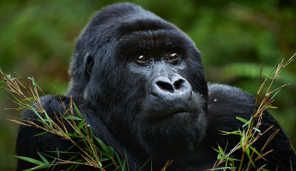
Epic Gorilla encounter


Gorilla Tracking Safaris and Wild Adventures
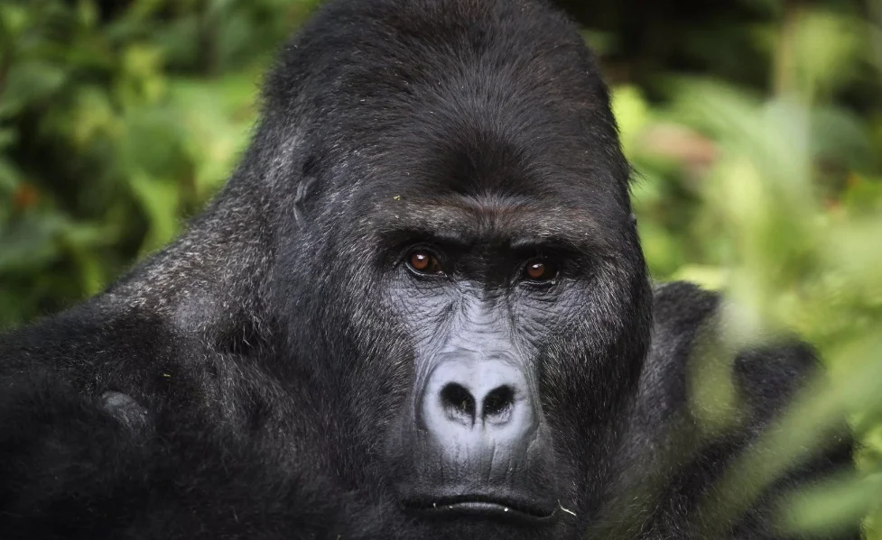
Gorillas tend to live in groups known as troops with a Silverback Gorilla as the head of the troop and also tasked with security duties in case of attacks from any predators. Bwindi Impenetrable National Park is ideal for Gorilla Trekking with up to 4 different Gorilla Trekking areas which include Buhoma, Ruhija, Nkuringo and Rushaga.
Below are highlights of out typical 4 day Gorilla Trekking Safari
Kampala - Bwindi Impenetrable Forest National Park
DAY 1
Arrival of your international flight. Picked up by the driver and transferred to a hotel.
Check-in at the booked hotel for dinner and overnight stay.
DAY 2
Kampala – Bwindi Impenetrable Forest National Park
06h30: After morning breakfast, you are transferred to Bwindi Impenetrable Forest National Park via Kampala- Masaka route. Stopover in kayabwe at the equator for a photo opportunity or craft shopping. Have Lunch in Mbarara Town, then proceed to Bwindi national park driving through the savannah grass land viewing the banana plantations and herds of Ankole cattle famous for their long horns. Reach the park in the evening check in your booked hotel for dinner and overnight.
Buhoma lodge – luxury
Trackers safari lodge – mid-range
Ruhija resort lodge- budget
DAY 3
Bwindi Impenetrable Forest National Park
06h00: Wake up very early in the morning for breakfast drive to the park headquarters for registration and a briefing by park rangers about gorilla trekking before commencing to the gorilla sanctuary,
07h00: Start Gorilla trekking; the ranger-guide takes you through the huge Bwindi Forest as you search for the giant apes. The venture of spending time observing these gentle and endangered giants is awesome and thrilling experience to be long relished but tiresome. Return to the lodge for lunch and resting, afternoon take a community walk to Buhoma village which gives you an opportunity to see how the people surrounding the park have survived for the generation living near the great forest. Return to the hotel for dinner and overnight stay.
DAY 4
Bwindi Impenetrable Forest National Park– Kampala – Entebbe- Departure
06h00: Early morning breakfast prepare and return to Kampala stopover in Igongo cultural centre for hot lunch and explore ancient history of the Ankole kingdom that has existed for years, proceed to Masaka-kayabwe at Uganda equator for photographs arrive Kampala in the evening check into a hotel for an overnight stay or evening transfer to airport for your home bound flight.

Memorable Bucketlist Experiences
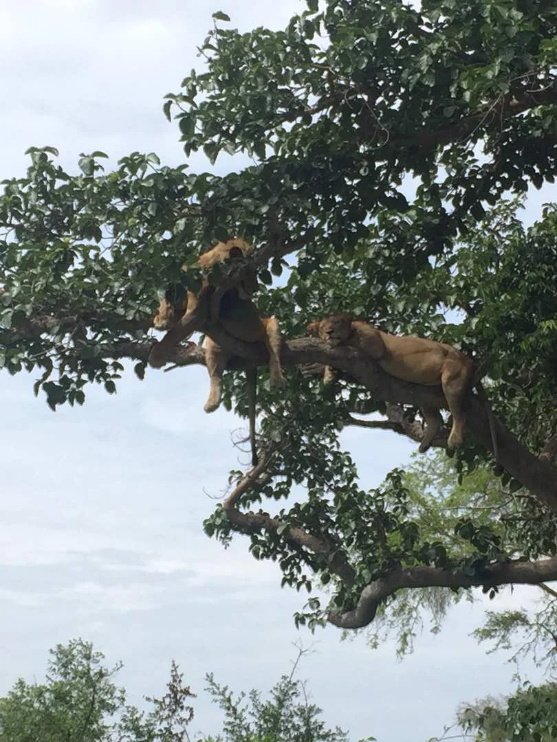
A fantastic capture & rare bucketlist moment for David Cole and his mum on a recent safari with Adyeri Creations @treeclimbinglions. Its not an everyday affair that travelers to Queen Elizabeth National Park get to see a full pride of tree climbing lions up in the trees.
A fantastic capture & rare bucketlist moment for David Cole and his mum on a recent safari with Adyeri Creations @treeclimbinglions. Its not an everyday affair that travelers to Queen Elizabeth National Park get to see a full pride of tree climbing lions up in the trees.

Congratulations to Rogers Muhumuza for yet again executing a successful and memorable safari.

And yes, David and his mum definitely did track and see the Mountain Gorillas in Bwindi National Park.
We know Uganda, drop us an email (travel@adyeri.com) to book your once in a lifetime memorable safari.

Uganda Safari
Popularly known as Masaba by the local people, Mount Elgon is an extinct volcano that last erupted over 24 million years ago. The mountain’s volcanic past is evident in the hot springs that still bubble out of the caldera floor.Some scientists judging from Mount Elgon’s 50 kilometer diameter reckon it may have been higher than Africa’s highest mountain, Kilimanjaro. Elgon’s highest peak Wagagai, reaches 4,321 meters above sea level.
Mount Elgon National Park, Uganda

About
Popularly known as Masaba by the local people, Mount Elgon is an extinct volcano that last erupted over 24 million years ago. The mountain’s volcanic past is evident in the hot springs that still bubble out of the caldera floor.
Some scientists judging from Mount Elgon’s 50 kilometer diameter reckon it may have been higher than Africa’s highest mountain, Kilimanjaro. Elgon’s highest peak Wagagai, reaches 4,321 meters above sea level.
Besides volcanic forces many other geological events have shaped Mount Elgon, the many crate lakes in the mountains caldera were formed by glaciers, which extended from summits down to about 3,500 meters during the Pleistocene era. The same glaciers gouged a deep gash out of the eastern wall, creating what is now the Suam Gorge.
Jutting westwards from the main mountain is the Nkokonjeru peninsula, a 2,350 meter ridge extending for about 20 kilometers. Years of land use practices and a growing population have had their effect on the area, which is one of the reasons the park was created.
Gazzeted on October 1993, the 1,145 square kilometer Mount Elgon National Park is primarily concerned with conserving and restoring the original forest that once covered the slopes, enabling the mountain to continue its essential role as a major watershed.
The area around the park is largely occupied by the Bagisu people, one of the few ethnic groups in Uganda that still practice traditional circumcision. Mainly agriculturalists they grow crops that include coffee, banana’s (locally know as matooke), millet, potatoes, beans and peas.
With the friendly people in the area, waterfalls, caves, hotsprings, mountain vegetation, peaks, the Suam Gorge, and the fascinating caldera itself, Mount Elgon is an exciting place to explore.
Getting there

Mbale, where the mountain park headquarter is located is 250 kilometers from Kampala, 97 kilometers from Soroti, 45 kilometers from Tororo to the south, and 224 kilometers from Moroto to the north. It is served y an excellent tarmac road from Kampala, Tororo and Soroti.
When to go
The best time to visit is during the dry season from June to August and December to February, with the latter preferable. However, even at other times of the year it is manageable although strong rains that cause landslides have been reported in recent times in area.
Where to stay
With the exception of hotels that are located in Mbale Town like Mbale Resort Hotel, there quite a number of lodges at the foothill of the mountain and camping sites on the hiking trails. Some of the lodges at the foothill of Mount Elgon National Park include; Kapkwata Guesthouse, Suam Guest House and the Sasa River Camp.
Sightseeing
It takes about four hours by road from Kampala to Mbale. To get there head east out of the capital on Jinja road which takes you past the Lugogo indoor stadium, through the middle of the KCCA sports grounds and the Kyadondo Rugby Stadium before you pass the Namanve Industrial park on your way out of Kampala.
After 80 kilometers, you come to Uganda’s third largest town, Jinja , the location of the source of the Nile and home to the Owen Falls Dam. From Jinja, stay on the main tarmac road heading east to Tororo, which is 125 kilometers away. On the way you pass some fairly major trading centers and towns like Bugembe and Iganga.
It’s a 45 kilometre drive from Tororo on the main tarmac road to Mbale, where the headquarters of the Mount Elgon National Park is located. Although an attractive town, Mbale itself does not have much of interest. The 30 minute walk from Mount Elgon Hotel to the town center is pleasant.
To reach the Mount Elgon National Park headquarters from the center of Mbale, take the road south east from the clock tower into Masaba road. The office is about one and a half kilometers from town opposite the Mount Elgon Hotel.
Mount Elgon is ideal for climbers seeking a less strenuous alternative to Rwenzori Mountains, as scaling Mount Elgon requires no technical climbing skills, and all major summits are accessible to hikers. The beautifully wooded slopes, smaller scale, and milder climate make Mountain Elgon a wonderful wilderness experience.
There are two main trails in the park: the Sasa and the Piswa, and any combination of the two trails is possible depending on your fitness levels. Ideally you should allow at least five days for a normal trip which includes climbing the highest peak, Wagagai but a seven day trip is more comprehensive also allowing you to visit the Caldera and climb Jackson’s point the second highest peak.

Another memorable safari
A VERY special sighting that our guests, the Eun Kyung family, had recently on a safari they booked with us!
A VERY special sighting that our guests, the Eun Kyung family, had recently on a safari they booked with us!


Book yours today to stand a chance to see amazingly special sightings like this!

Uganda Safari
Gazetted in 1993, Semuliki National Park lies in the Semuliki Valley northwest of Fort Portal. Formerly a forest reserve, the 220 square kilometer park is virtually untouched by development of any sort making it a great place to spend a few days just relaxing and exploring. The park shares its unique ecosystem with the Ituri Forest, across the Semuliki River in the Democratic Republic of Congo.
Semuliki National Park

About
Gazetted in 1993, Semuliki National Park lies in the Semuliki Valley northwest of Fort Portal. Formerly a forest reserve, the 220 square kilometer park is virtually untouched by development of any sort making it a great place to spend a few days just relaxing and exploring. The park shares its unique ecosystem with the Ituri Forest, across the Semuliki River in the Democratic Republic of Congo.
Semuliki is the only park in Uganda primarily made up of tropical lowland forest, which is characterized by more diverse vegetation. Its wetter and the vegetation is more dense with rains for the bigger part of the year. You can experience a good taste of local life by visiting one of the nearby markets.
Getting there
Sempaya, where the road first meets the park boundary is roughly 41 kilometers from Fort Portal and thus 363 kilometers from Kampala. Ntandi where the park headquarters is located is a few kilometers further along the same road.
When to go
Be prepared for wet weather most of the year. If you’re interested in hiking in the area, this is best during the dry seasons from June-July and December –February. No matter when you travel please carry hiking boots.
Where to stay
It’s better to stay in Fort Portal and start off for Semuliki National Park the following morning. In Bundibugyo just south of the park you can access some great accommodation facilities.
Sightseeing
From Fort Portal head north east out of town on Lugard road and then turn left into Saka road opposite the golf course eight kilometers from town you get to Lake Saka, a lovely crater lake. If you continue along Saka road it curves west and eventually joins up with the road that heads towards Bundibugyo.
For Semuliki National Park head west out of Fort Portal town on Bwamba road towards Bundibugyo. After 41 kilometers you will reach the park’s Hot Springs Office at Sempaya where the road first meets the Semuliki National Park boundary. There is a number of hot springs in Sempaya one of which is 26 meters wide with temperatures of about 106 degree Celsius. The water and the surrounding land are rich in salt and sulphur which attracts an unusually large population of shoebirds.

A short nature trail loops around the hot springs at Sempaya. Another more adventurous hike from Sempaya leads along the park boundary north to the Semuliki River and the Democratic Republic of Congo border. The Semuliki River provides another of park’s micro habitats, with vervet monkeys playing along the river banks.
Hiking through the park takes you through a variety of habitats; including clearings of grasslands, bits of swamp. Isolated stands of palm oil, acacia or glimpses of bamboo swamp. Animal you expect to see as you hike include elephants, buffalo, leopard, civet, hippos and crocodiles as well as different species of primates which may include the white colobus monkey, red tailed monkey, baboon and vervet monkey.
The park is also home to some 400 bird species and 300 different species of butterflies

Uganda Safari
At the extreme south western tip of Uganda on the borders with Rwanda and the Democratic Republic of Congo lies Uganda’s smallest national park covering 33.7 square kilometers.The Mgahinga Gorilla National Park established in 1991 is also one of Uganda’s newest national parks. It is an integral part of the Virunga Conservation Area and is contiguous with Parc National Des Volcans in Rwanda and Parc National Des Virunga in the Democratic Republic of Congo (DRC)
Mgahinga Gorilla National Park

About
At the extreme south western tip of Uganda on the borders with Rwanda and the Democratic Republic of Congo lies Uganda’s smallest national park covering 33.7 square kilometers.
The Mgahinga Gorilla National Park established in 1991 is also one of Uganda’s newest national parks. It is an integral part of the Virunga Conservation Area and is contiguous with Parc National Des Volcans in Rwanda and Parc National Des Virunga in the Democratic Republic of Congo (DRC)
Three extinct volcanoes lie within the park: Mount Muhabura, at 4,127 meters; Mount Gahinga at 3,475 meters; and Mount Sanbinyo at 3,645 whose peak lies along Uganda’s border with Rwanda. Mgahinga is afro montane tropical rainforest, and the vegetation is typical of this terrain, with a montane forest belt, a bamboo zone, an ericaceous belt, and an alpine zone. The park is surrounded by the terraced fields of the Batwa and Bafumbira people. The Batwa lived in the forest as hunters and gatherers but have since resorted to farming.
Most of the lower forest in the park has been lost as a result of human pressure over the last five decades. Bamboo and alpine habitat are largely all that remain. The local people benefit from the park with a portion of gorilla permit fees going to local development and conservation.
Getting there
Kisoro where Mgahinga Gorilla National Park is located is 496 kilometers from Kampala, 213 kilometers from Mbarara and 66 kilometers from Kabale.
When to go
As a rainforest the park is always wet even more so during the rainy seasons of April – May and October – November. But as Gorilla permits are hard to come by for only a limited number of people per day, it’s advisable to track the Gorillas when you can. It’s important to note that Gorilla permits are discounted during the months of March-May and September – November with visitors only paying 450 USD as opposed to the 600 USD paid during the peak seasons of June- August and December – February.
Do the Math and compare that with a Rwanda Gorilla Permit that costs 1,500 USD all year round and you will notice that you will be saving a whooping 1,050 USD.
Sightseeing
From Mbarara continue towards Kabale on the main tarmac road to the south west through the towns of Kinoni and Ndejja to Ntungamo, the headquarters of Ntungamo district a 66 kilometer drive from Mbrarara. There the main road heads more directly southern through Rubare, Rushenyi, and Bukinda to Kabale, which 86 kilometers past Ntungamo.
Kabale in southwestern Uganda is the unofficial capital of the Kigezi region and is a beautiful mountainous area with steep sided hilly slopes. It s an area crisscrossed by numerous tracks and paths making it a haven for hikers. One of the most beautiful attractive places is Lake Bunyonyi , which is situated over a ridge to the north west of Kabale Large and irregular Lake Bunyonyi features a number of islands and is surrounded by heavily cultivated hillsides.
From Kabale its about 66 Kilometers by road to Kisoro, the road offers spectacular views of the peaks of the Virunga mountain range. If you feel like exploring in Kisoro while waiting for the Gorilla tracking activities, you can visit lakes Mutanda and Muhele a few kilometers north of the town.
Getting to the Gorillas
Before tracking the Mountain Gorillas you have to make an advance payment for which a Gorilla permit shall be issued by the Uganda Wildlife Authority. The Uganda Wildlife Authority will also give you updated information regarding Gorilla Permit availability and current fees. The gorilla viewing situation is constantly changing so we avail you with updated information prior to travelling.
Gorilla Tracking permits cost 600 USD for Foreign Non-Residents and 400 USD for Foreign East African Residents (You qualify to be an East African Resident if you reside in Uganda, Kenya, Rwandaand Tanzania)
On the day you intend to track the Gorillas you have to be at the Park headquarters at Ntebekko Camp at the mountain foothill by 0830. Once there be prepared for some strenuous walking and scrambling through thick undergrowth. You must be in good physical shape. To protect the Gorillas from disease, children under the age of 15 and people who are ill are prohibited from entering the park. Keep in mind that Gorillas are primates and there DNA is closely linked by 97% with that of humans; so they can contract disease from humans like flu that’s why it’s advisable to stay clear when you’re ill. Follow you tour guide’s instructions because these animals are wild and capable of killing people. There are less than 800 mountain gorillas in the world of which almost half live in the Virunga conservation area and the other half in Uganda’s Bwindi Impenetrable National Park, about 25 kilometers north of Mgahinga. If you’re taking photographs remember not to use the flash feature on your camera because the Gorillas are dark and their habitat is dark. Carry along a specialized camera or smart phone that won’t necessitate using flash.
Besides Mountain Gorilla Tracking, other activities on offer at the Mgahinga National Park include tracking the Golden Monkey and the park also supports uniquely adapted animals and plants. More than 185 bird species have been recorded in the area.
There are also a number of exciting hiking options to take while at the park which showcase Mgahinga’s dramatic views, lush vegetation and wildlife. Visitors may for instance attempt the full day challenging climbs to the tops of Mount Muhabura and Mount Gahinga, who summits offer great view of Uganda, Rwanda and the Democratic Republic of Congo. You’re bound to see lots of unique alpine vegetation and a small volcanic lake hidden away at the top of Mount Muhabura. For safety reasons climbing the nearby Mount Sabinyo is not recommended but you can hike through the beautiful and dramatic Sabinyon Gorge.
Another outing can be arranged at the Garama Cave, where humans once sheltered during the late Iron Age. The cave rumoured to cut through to Rwanda is about two kilometers from Ntebeko Camp. The visit last two to three hours and does not require any special hiking skills.
Mgahinga Gorilla National Park also features a 13 kilometer nature trail, providing the opportunity to learn about the ecology and wildlife of this park. During the walk you might see the Golden Monkeys, Duikers and Bushbucks. For trekking to see the gorillas or going on any of the organized hikes, good hiking boots or gumboots (Wellingtons), good rainwear and warm clothing are recommended.

Memorable Safari Experiences
Every week we select the best images from our Guests & Guides - have a look at some of our favorites!

At Adyeri Creations we combine affordability with comfort and deliver the perfect safari experience in the delightful Pearl of Africa.
New Year, great safaris; We strive to deliver memorable Gorilla Tracking and Wildlife Safari experiences.
Be enchanted by these images, taken on a recent trip with, Cara Picton and our guide Tom. We thank Tom for a job well done.


Uganda Safari
Gazetted in 1982, this park not only encompasses Lake Mburo but also four other smaller parks. It’s easy accessibility from Kampala makes it a favorite destination for short trips. Mainly Savannah with scattered acacia trees, the park features rolling hills, open grass valleys, thickets, woodlands, and rich wetlands. It is home to a wide variety of wildlife and bird life; it is also outstanding in that it has a strong community extension component, trying to work closely with the local people to conserve the wildlife and other natural resources both inside and outside the park.
Lake Mburo National Park

About
Gazetted in 1982, this park not only encompasses Lake Mburo but also four other smaller parks. It’s easy accessibility from Kampala makes it a favorite destination for short trips. Mainly Savannah with scattered acacia trees, the park features rolling hills, open grass valleys, thickets, woodlands, and rich wetlands. It is home to a wide variety of wildlife and bird life; it is also outstanding in that it has a strong community extension component, trying to work closely with the local people to conserve the wildlife and other natural resources both inside and outside the park.
Getting there
The main turn off to Lake Mburo National Park’s Nshara gate is approximately 110 kilometers from Masaka, 219 kilometers from Kampala and 35 kilometers from Mbarara. Its served by the Kampala –Kabale tarmac road although there is a 24 kilometer dirt road to the park gate.
When to go
The park is enjoyable at any time of the year but is particularly green and fresh just after the April-May and October-November rains.
Where to stay
Ranging from Rwakobo Rock, Mihingo Lodge to Mburo Safari Lodge, there ample accommodation facilities that are ideal for a memorable safari experience.
Sightseeing
Head south west on the main road from Masaka, where 77 kilometers further on, you’ll come to the town of Lyantonde. If you are interested in African history and archaeology, you may at this point want to divert from the route to Lake Mburo Park. Turn right on the dirt road from Lyantonde that leads to the town of Ntusi, 61 kilometers off the main road. Although a modern village, Ntusi lies on the site of what is thought to be the most ancient large settlement in Uganda. Strong eveidence suggests that the people of once lived there gave rise to the legendary and mysterious Batembuzi gods, who play a central role in Ugandan folklore.

Legend has it that the first empire in what is now western Uganda was that of the Batembuzi. Oral history places the Batembuzi empire at between 1100AD and 1350AD, and evidence in the Ntusi region confirms that a highly centralized society existed there as early as the 11th century. There are interesting displays regarding the Ntusi region at the Uganda museum in Kampala.
The ancient town is thought to have been the largest settlement in Sub-Saharan Africa when it reached its pinnacle in the 12th and 13th centuries. Its believed to have been the capital of an ancient empire stretching all the way to Lake Albert in the north and thought by some to be the source of the Batembuzi legends. Evidence of iron smelting, wood carvings and ivory have been found there by archaeologists.
From Lyantonde on the main Masaka-Kabale road, continue to head south west. In just 13 kilometers at the 50 kilometer marker you will see a signpost for the first turnoff to Lake Mburo National Park’s Nshara gate. There is a second turn off leading to the Sanga gate, 15 kilometers further along the main road at the Sanga trading center. It is a 21 kilometer drive from Sanga Trding center to the park headquarters.
The east side of park features undulating, low hills broken by rocky outcrops, while in the west a series of rugged hills overlook flat bottomed, open valleys. The grassy valleys offer the best game viewing opportunities, with Impalas being the most remarkable species there, as its found no where eels in Uganda. Herds of Buffalo, Zebra and Eland can also be found, particularly by the waterholes during the drier seasons. Oribi and Topi seen in pairs and small groups are abundant. You’ll also spot families of comical warthogs and occasionally reedbuck which hide in the grass.
The acacia and olive woodland harbor shy bush duikers, as well as waterbuck, vervet monkeys and baboons. Keep an eye out for the elusive Klipspringers and rock hyrax on the granite outcrops in the west of the park and in the rocky hills in east.
The five lakes in the park and several other that lie just outside the southern park boundary are home to crocodiles and hippos which can be seen grazing out of the water on cool mornings. The surrounding papyrus swamps hide the beautiful Sitatunga, which has narrow elongated hooves that allow it to ove easily over marshy, unstable grounds.
Predators are rarely seen in the park, which is why it’s possible to walk anywhere within the park borders provided you are accompanied by a ranger. Either full or half day walking safaris, a wonderful African experience can be arranged.
Bird enthusiasts will delight in this park which offers a variety of water and dry land species, including the rare Shoebill Stork, the Abyssinian ground hornbill, and the sadddlebill stork. The forested area of the park are home to the Narina trogon.
As well as walking safaris and the traditional game drives, the park also offers a self guided nature trail and an interpretation center if you wish to learn more about the park, its wildlife and its ecosystem.
For a first hand view of Lake Mburo we suggest going on a two hour boat trip which is perfect for searching out birds, such as kingfishers and herons, at the water’s edge, watching animals come down to drink water and getting an eyeball to eyeball look at the hippos and crocodiles keep in mind that our tour guide will ensure that you keep a safe distance.

Uganda Safari
The vast, semi arid plains of Uganda’s north east are home to one of the country’s real treasures: Kidepo National Park. Indeed part of the park’s appeal is its remoteness guaranteeing that the visitor won’t be fighting off mini buses in an attempt to see wildlife. Gazetted in 1962, Kidepo Valley National Park is truly one of Uganda’s most spectacular parks, offering some of the wildest and most magnificent scenery to be found in East Africa, relatively un-spoilt by development.
Kidepo Valley National Park

About
The vast, semi arid plains of Uganda’s north east are home to one of the country’s real treasures: Kidepo National Park. Indeed part of the park’s appeal is its remoteness guaranteeing that the visitor won’t be fighting off mini buses in an attempt to see wildlife. Gazetted in 1962, Kidepo Valley National Park is truly one of Uganda’s most spectacular parks, offering some of the wildest and most magnificent scenery to be found in East Africa, relatively un-spoilt by development.
The Kidepo Basin lies in a mountainous country side at an altitude of between 900 and 1200 meters and in encircled by wooded hills. It is dominated by 2750 meter Mount Morongole on its eastern flank and by the forested Lotuke in Sudan with peaks rising to more than 2700 meters.
The park covering 1,442 sq.kms is in the far north eastern horn of the country and it borders South Sudan and near Kenya. This part of the country is generally referred to as Karamoja district where the famous Karimojong pastoralists graze their cattle across the plains.
Getting there
The ideal way to Apoka where the park headquarters and rest camp are located, is by air charter although the accessing the park by road is also possible though gruesome. Apoka is 504 kilometers from Kampala, 162 kilometers from Kitgum, and 255 kilometers from Moroto.
When to go
The best time to visit kidepo is during the dry season between December and early April. During the Kidepo rainy season from April to September travel is not easy and game is difficult to locate because of long grass.
Where to stay
The growth of the tourism sector in Uganda has led to the establishment of some luxurious and budget accommodation facilities in Kidepo Valley National Park. Facilities like Apoka Safari Lodge and Nga'Moru wilderness camp offer accommodation services within the park.
Sight Seeing
From Mbale head out of town on the Kumi road. You can take a couple of side trips along the this road to see the rock painting at Kakoro and Nyero . But to drive to Kidepo, turn right a few kilometers of town on the main gravel road heading north.
After the turnoff, you pass through the village of Sironko and soon afterwards the turnoff to Sipi. After about 50 kilometers you come to the village of Chepsikunya. Shortly after this the road passes through the lower part of the Pian-Upe Game Reserve one of the three large adjoining reserves in Uganda’s north east . The 2314 sq.km of rolling plains of black cotton soil run from the river in the south of Napak on the boundary of Bokora Game Reserve in the north. The area which includes Pian-Upe, Matheniko and Bokora reserves is known as the Bokora corridor.
From Chepsikunya village, its about 140 kilometers before the Moroto turn off which is 10 kilometers east of the Main road. There is an airstrip there as well as petrol, police, a hospital and the Mount Moroto hotel making it a good place to break your journey.
Back on the main road at the Moroto turn off head north once again. After about 30 kilometers you pass through Lokichar, and shortly thereafter the road travels directly across the corridor linking the Matheniko Game Reserve and the Bokora Game Reserve. The Matheniko to the right of the road covers about 1,605 sq.kms but there is not much game left. To the left of the road is the tip of the huge Bokora Game Reserve a large dry flat plain where several species of antelopes still roam.

From Lokichar its about 55 kilometers to the town of Kotido, where there is a police station, and another 41 kilometers before the main road takes a sharp bend to the west. Shortly after this bend you come to the village of Koputh where you turn right to continue north on the main gravel road. After about 24 kilometers you pass through the town of Kaabong and then 69 kilometers later you eventually reach your destination: Apoka.
The park consists of two shallow valley systems with rugged, dry, mountain terrain. The area’s remarkable variation in altitude has created a profusion of habits within the park including montane forests, grassy plains, open tree savannah, dry thorn bush, thick woodlands; borassus palm forest, and Koppies.
During the six dry months of the year in Kidepo, wildlife is attracted to water sources that remain in Narus Valley in the South West of the park. There is great diversity of Wildlife: 80 species more than in any other park in Uganda.
You can expect to see Zebra’s, large herds of elephants, elands, lesser kudu and buffaloes. Visitors can get a good look at this bountiful wildlife and bird life from several game viewing loops in the Narus Valley where most of the game is concentrated.
In addition the park nature exhibit at the Apoka headquarters is open to visitors and contains Specimens of Lions skins, giraffe skulls, butterflies, scorpions and photographs of the rare albino buffalo.
If you’re interested in a taste of the local life a visit to the local Manyattas (Karimojong homesteads) can be arranged for up close experience of see the traditional clothing, stools, spears, headdresses, bows, arrows, knives and jewellery.

Uganda Safari
Although it’s contiguous with Queen Elizabeth National park to the south west, the 766 square kilometer Kibale National Park is much wetter and contains a unique moist forest habitat with an extremely high diversity of wildlife and flora.Gazetted in October 1993, Kibale contains what is probably the most accessible of the country’s large forests.
Kibale National Park

About
Although it’s contiguous with Queen Elizabeth National park to the south west, the 766 square kilometer Kibale National Park is much wetter and contains a unique moist forest habitat with an extremely high diversity of wildlife and flora.
Gazetted in October 1993, Kibale contains what is probably the most accessible of the country’s large forests.
The Park includes what used to be the Kibale Forest Corridor Game Reserve, established in 1964 to allow additional habitat for the then large herds of wildlife in Queen Elizabeth National Park. It also served as an important stop to the migratory routes to game reserves and Murchison Falls National Park further north for the huge herds of elephants that once roamed Uganda’s western frontier.
The altitude ranges from 1590 meters in the north to 1110 in the south, and to a large degree is responsible for the differing vegetation within the park. It is a medium altitude transitional moist ever green forest occurring at elevations between montane forest and mixed tropical deciduous forest.
Getting there
Kanyanchu, where the park’s visitor centre is located is 35 kilometers south of Fort Portal, 357 Kilometers from Kampala and six Kilometers north of Bigodi village.
When to go
Kibale National Park can be visited at any time of the year, but expect cool nights particularly during the rainy seasons of April-May and October-November.
Where to stay
A wide range of accommodation options exist ranging from budget to luxurious accommodation. Crater Safari Lodge and Kibale Safari Lodge are some of the accommodation facilities on offer at the park.
Sightseeing
From Fort Portal head north east on the Lugard road, turning right on Kamwenge road immediately before you cross over the Mpanga river. The Kamwenge Road follows the river in an easterly direction from a short stretch before it dips sharply south. About 35 kiolmeters from Fort Portal, after crossing through a section of Kibale National park, you arrive at the Kanyanchu Visitor Centre.
From Kanyanchu guided walks can be arranged along well marked tracks in search of many types of primates found there including chimpanzees. The walks last anywhere between two to three hours.
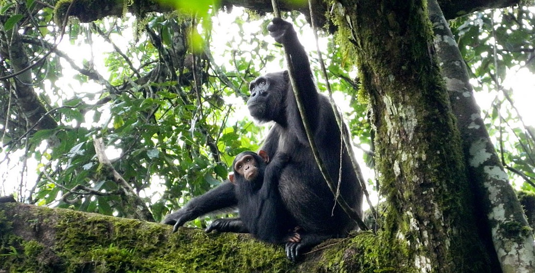
The primates of Kibale have been the object of much research with the forest supporting the highest number of primates in Uganda and one of the highest primate densities in the world. There are twelve species of primates of which three are nocturnal. Red colobus monkeys, as well as the white and black colobus can be found at the park. The red colobus monkey is a rare species in Uganda and is exclusively found in Kibale National Park where it exists at very high density and can usually be seen of the forest walk from Kanyanchu. Guenon’s present include red tailed, blue and L’Hoest’s monkeys with the red tailed most commonly seen in Kanyanchu area. L’Hoest’s monkeys are mainly seen along the Kibale main road.
The most anticipated sighting by visitors to the park however is the chimpanzee. Several communities of the fascinating primates have been habituated and can often be seen.
The park also supports a huge diversity of other wildlife including bushbuck, red duiker, blue duiker, bush pig, Civet Buffalo and giant forest hog.
About 325 species of birds are reported in Kibale, a number of which are endemic. In addition there are more than 144 species of butterflies and a large number of moths and insects.

Uganda Safari
Murchison falls was gazette in July 1952, a few months after the National Park’s act was passed. The spectacular 3840 sq. km park, the country’s largest is known for its scenic beauty and abundant flora and fauna although it suffered considerably during the late 1970’s and early 1980’s, which had a disastrous impact on its once abundant game. However, with animal population consistently growing, and Murchison falls may soon regain its reputation as one of Africa’s favorite destinations.
Murchison Falls National Park

About
This park owes its existence to a serious outbreak that decimated Uganda’s human population between 1898 and 1915. As the only effective way known to combat the disease was to evacuate the region between 1907 and 1912.
Murchison falls was gazette in July 1952, a few months after the National Park’s act was passed. The spectacular 3840 sq. km park, the country’s largest is known for its scenic beauty and abundant flora and fauna although it suffered considerably during the late 1970’s and early 1980’s, which had a disastrous impact on its once abundant game. However, with animal population consistently growing, and Murchison falls may soon regain its reputation as one of Africa’s favorite destinations.
Take note that the park was briefly renamed Kabalega Falls National Park, and remains as such on some maps.
Murchison Falls National Park offers some of the wildest and most pristine scenery in Africa. Lush plains are scattered with palms, rich forest and growing herds of animals.
And, of course there are the magnificent Murchison Falls, where the mighty 50 meter wide River Nile squeezes through a six meter cleft in the rocks to drop 43 meters in a cascading thunder of water forming an inevitable mist and beautiful rainbow. The River Nile, in fact is the most prominent feature of the park, bisecting it from East to West. The north most tip of Lake Albert forms western boundary of the park, so the area is extremely well watered and fertile.
Getting there
Using the most direct route, Paraa where Murchison Falls is located is 303 kilometers from Kampala, 86 kilometers from Masindi, 142 kilometers from Hoima and 109 kilometers from Gulu. It is served by road from Kampala most of which is tarmac and can also be reached by air charter, using the all weather airstrip of Pakuba, about 10 kilometers northwest Paraa.

When to go
The park is lovely at any time of the year, but most visitors choose to avoid the rainy seasons of April-May and October-November.
Where to stay
Murchison Falls has experienced an enormous development of accommodation facilities in recent years. At Paraa, the Paraa Safari Lodge is equipped with all that a visitor would ever ask for. There is also the Sambiya River Lodge on the southern bank of the river not far from Paraa. There are also some rustic campsites near the top of the falls, for which you must totally be self sufficient. Paraa Safari Lodge and Chobe Safari Lodge are some of the luxurious lodges on offer at the park.
Sightseeing
From the Old Kampala Road roundabout that circumvents the Gaddafi Mosque, head north on boundary close which becomes Sir Apollo Kaggwa Road. As you travel out of town on this road (which is signpost to Bombo, Luwero and Gulu), you pass the extensive grounds of the prestigious Makerere University on your right. There is nothing much to see of note along the way, although you pass through numerous small towns, each with its own colorful ambience particularly on market day. After about 119 kilometers you get to the town of Nakasongola where the main tarmac road veers left, following the meandering contours of Lake Kyoga.
The River Nile flows Northwards from Owen Falls Dam into this shallow papyrus and water lily girt lake, which is 100 kilometers long and covers a total area of 4,427 square kilometers. Much of it is Swamp; its one of Africa’s greatest wetland ecosystem with prolific bird and lacustrine life. To take a closer look at the lake, you can make a 23 kilometer detour on the dirt road that leads north of Nakasongola to the Lake’s edge of Lwampanga village
From Nakasongola it is a 98 kilometer drive northwest to Masindi but take care: after 58 kilometers the road forks just after you cross the Kafu River, with a right fork the main tarmac road, north to Gulu and left to Masindi.
A worthwhile side trip, only 31 kilometers away, is to take the right fork and stay on the tarmac until you get to the village of Rwekunye where you turn right to the town of Masindi port on the banks of the River Nile. The town has a colorful open market, full of hundreds of friendly locals.
To reach Masindi, return to the main road and take the left fork. You will reach Masindi after driving for 40 kilometers. The land to the west of Masindi known as West Nile region is Uganda’s main tobacco growing area.
While Masindi has nothing much to speak of; it’s a base from which you can visit the historical sites in Hoima and the Budongo Forest Reserve that’s boast of a high density of primates. The Masindi Hotel about a kilometer out of town on the road north to Murchison Falls is the “upper range’ hotel although there are several guest houses. Only five kilometers out of town is the Bunyoro kings palace on Kihande hill which is worth a visit.
The Hoima historical sites and the Budongo Forest Reserve may be visited separately or as part of a circuit drive. To do the latter head south west out of Masindi Town towards Hoima, some 56 kilometers away. About four Kilometers before you reach Hoima town, on the left of the road are the Mparo Tombs, where the Bunyoro King who died in 1923 and several of his successors (including his son Sir Tito Winyi) are buried. The burial site is a large enclosure made of natural materials, while Kabalega’s grave is housed in domed construction similar to that of the Kasubi tombs in Kampala although much smaller. The grave is surrounded with many of King Kabalega’s personal effects. Outside the main enclosure is a plaque where Kabalega met Emin Pasha in 1877. Remember to take off your shoes before entering the main tomb.
It was from Mparo that Kabalega led his raids into the neighboring kingdoms of Tooro and Buganda, although he was driven from his capital by the British in 1891and turned to guerilla warfare. Eventually the British captured him after a series of forts were built in the Lake Albert Region in 1984. You can see of the main fort travelling to Hoima town and turning north on the road leading to Butiaba. After only 3 kilometers you reach Katasiiha where the main fort was. All that remains today is an 8 meter deep trench, now filled in and a cave that was used as an arsenal. The fort like the others the British used in the area was built by General Colville.
Continue your journey north on the Butiaba road. About 32 kilometers west of the town of Kigorobya on the shores of Lake Albert are the Kibiro hot springs and salt works where traditional methods of extracting salt are quite evident. A boat can be hired for a tour of Lake Albert on request. The Lake particularly the northern near Murchison Falls National Park is a real fishing center with plentiful tilapia, Nile perch and tiger fish.

Uganda Safari
Close to Mgahinga National Park is Bwindi Impenetrable National Park, where you may even have an even better chance of seeing the rare mountain gorilla, as seven groups are habituated there. As it's name "impenetrable" implies, this park is not quite accessible as Mgahinga, but its well worth the effort of going there.
Bwindi Impenetrable National Park

About
Close to Mgahinga National Park is Bwindi Impenetrable National Park, where you may even have an even better chance of seeing the rare mountain gorilla, as seven groups are habituated there. As it's name "impenetrable" implies, this park is not quite accessible as Mgahinga, but its well worth the effort of going there.
Like Mgahinga, Bwindi which was gazetted in 1991, is one of the country's newest national parks. It covers 331 square kilometers which makes it the third largest forested area in Uganda and lies on the Democratic Republic of Congo border, adjacent to Parc National des Virungas of Democratic Republic of Congo. Situated on the edge of the western Rift Valley on the highest block of the Rukiga highlands, its one of the largest natural forests in East Africa containing both montane and lowland forest vegetation.
Bwindi ranges in altitude between 1,160 and 2,607 meters. The highlands on which the park sits consist of old (Precambrian) rock, much eroded and altered. Like Mgahinga, much of the vegetation is typically tropical rainforest, with a very dense thick undergrowth hence the name "impenetrable". Make no mistake about it tacking gorillas in this area is strenuous work.
Bwindi's 120 plus species of mammals make it one of the richest ecosystems in Africa. Primates are particularly abundant and include the mountain gorilla, chimpanzee, blue monkey, red-tailed monkey, L'Hoest's monkey, black and white colobus monkey, baboon, potto and Demidoff's galago. Other mammals present include the bush pig, giant forest hog, clawless otter, golden cat, side stripped jackal and many species of bats and rodents.
Bird lovers will take delight in the fact that some 346 species are found there of which 184 are typical forest species. In addition Bwindi is home to more than 14 species of snakes , 27 species of frogs and toads, six chameleons and 14 Lizards, skinks and Geckos. You're also bound to notice the incredible variety of butterflies in the park: more than 202 species ave been identified so far.
If you're more into flora than fauna, you'll be interested to note that there are more than 163 species of trees in Bwindi, 10 of which occur nowhere else in Uganda and 16 of which show a very limited distribution elsewhere in Uganda.
Getting there
Bwindi is located in the South Western part of Uganda with Buhoma from where the gorilla is viewing is conducted is 120 kilometers from Kabale district (through Bulema and Butogota) , 550 kilometers from Kampala city and 267 kilometers from Mbarara district.
When to go
Like Mgahinga, Bwindi National Park is a rainforest and thus is wet all year round, although the course of the rains increase during the seasons of April - May and September - October. Ideally the best time to travel would be during the dry seasons of May - August and December - February.
Where to stay
There is a wide array of accommodation facilities on offer at Bwindi National Park ranging from budget camps to luxurious lodges depending on the Gorilla group that you would like to track.
At Buhoma, visitors can stay in simple bandas or camps using their own tents in a community run campsite.
How much does a Gorilla permit cost?
The prices of Gorilla permits in Uganda are normally fixed and vary depending on the time of the year you wish to track the Gorillas. Peak season Gorilla permits cost 600 USD for foreign non-residents and 400 USD for foreign East African residents.
During the Off Peak season which covers the months of April, May and November; Gorilla permits cost 450 USD.
Gorillas and more
Mountain Gorilla Tracking is the major attraction in Bwindi National Park. There are seven groups and these include;

- Mubare Group: Habituated in 1991, this group is found in the Buhoma area of the park
- Rushegura Group: This group is found in the Buhoma area
- Habiyanja Group: Habituated in 1997, this group is found in the Buhoma area
- Mishaya Group: This is is found in the Rushaga area and was originally part of the Nshongi group
- Nshongi Group: This group is found in the Rushaga region and consists of 25 gorillas
- Nkuringo Group: This group comprised of 19 gorillas and is found in the Nkuringo area of Bwindi
- Bitukura Group: This group is found in the Ruhija area
Hiking
As in Mgahinga, there are other things to see in Buhoma area of Bwindi beside the gorillas. There are a number of hiking trails in the park, but visitors must arrange a day in advance for a guide to accompany them. Three trails begin in Buhoma, including the Muyanga River Trail which is an ideal short walk for visitors with little time to spare.
Alternatively, try the Waterfall Trail, which follows the Muyanga River upstream as it tumbles down the steep slopes south-east of Buhoma, flowing through a series of waterfalls before entering the camp area.
The Rushuura Trail will afford you some fantastic views across the western Rift Valley floor with the Democratic Republic of Congo's Park National des Virungas providing a particularly spectacular back drop.
Buhoma is an ideal place from which to watch primates and birds. You'll see many monkeys along the roads, around the periphery of the park, and at the forest edge.
This is also the richest site for birds in the park, with some 190 species on record. Of particular interest are the Kiva ground thrush, white-bellied robin chat, red-throated alethe, collared apalis, short tailed warbler, yellow-eyed black fly catcher, Rwenzori Batis, blue-headed sunbird, strange weaver , and Shelley's crimsonwing.
The Mubwindi swamp in the centre of the park is a three hour hike from Ruhija. The scenic walk passes through a beautiful forest and affords fine views of Virunga volcanoes.

Uganda Safari
Popularly known as the Mountains of the Moon and was discovered by white explorers in 1889. Everyone from experienced hikers to casual day hikers find the Rwenzori Mountains National Park a magnificent environment, with its non-volcanic mountains capped with snow, massive ice-rime sculptures, awe-inspiring vegetation and unique fauna. The mountains are 120 kilometers long and 48 kilometers wide were forced up during the creation of the Great Rift Valley.
Rwenzori Mountains National Park

About
Popularly known as the Mountains of the Moon and was discovered by white explorers in 1889. Everyone from experienced hikers to casual day hikers find the Rwenzori Mountains National Park a magnificent environment, with its non-volcanic mountains capped with snow, massive ice-rime sculptures, awe-inspiring vegetation and unique fauna. The mountains are 120 kilometers long and 48 kilometers wide were forced up during the creation of the Great Rift Valley.
At the centre of the range are six snow capped peaks. The highest Mountain of the range, Mount Stanley is the third highest mountain in Africa after Mounk Kilimanjaro and Mount Kenya. Mount Stanley’s highest peak, Margherita rises 5,109 meters above sea level. Other peaks in the range include Alexandria, 5,083 meters; Speke, at 4,890 meters; Emin at 4,791; Gessi at 4,715; and Luigi di Savoia at 4,627 meters. Interestingly more people visit the Rwenzoris to explore the vegetation than to climb the glaciers and peaks. Because of the strange evolutionary pattern, common plants grow to absurd proportions. Lobelias weigh in at 60 kilograms while heather shoots upto 10 meters.
The people on the lower slopes of the Rwenzori Mountain are the Bakonjo. Strong and energetic, they are well suited to life in the mountains, which are an integral part of their traditional beliefs.
Over 500,000 Ugandans living below the park boundary are dependent on the park watershed for year round agricultural production. Major crops include coffee, beans, maize, yams, Irish potatoes, and wheat.
Getting there

Ibanda, the nearest town to Nyakalengija Park headquarters (the starting point for climbing in the mountains), is about 69 kilometers from Fort Portal, 25 kilometers from Kasese, and 389 kilometers from Kampala. It is served by a good tarmac road from both Fort Portal and Kasese. The nearest large town Kasese was served in the past by rail from Kampala but has an airstrip in place to accommodate air charters.
When to go
Constant mist covers the mountains all year round. The driest months are usually July and August, and December to February. Visits at any other time might be disappointing.
Where to stay
Along the central hiking circuit, camping sites are available at convenient stopping points. Accommodation is also available in Kasese at the Margherita Hotel and several lodges.
Sightseeing
Head south out of Fort Portal town on Kyebambe road towards Kasese. About 5 kilometers out of town on the left side of the road, stand at the Karambi tombs, where Toro King Kasagama and his son Rukidi II are buried. There’s not much else to see before the Rwenzori National Park turnoff but the scenery along the way is beautiful, and you pass through several small towns. Some 54 kilometers from Fort Portal you come to the turn off to Ibanda and the Nyakalengija Park headquarters. From there its another 10 kilometers to Ibanda and another 5 kilometers through banana and sugar plantations before you reach Nyakalengija where the hiking trail begins.
The usual trip to Rwenzori Mountains lasts seven to nine days, which is just long enough to hike the well travelled central circuit trail. Shorter trips can also be arranged but they do not reach the high mountains. It is best to allow a minimum of six days even for shorter trips. No special climbing equipment is necessary unless you attempt one of the summits although you have to keep in mind that hiking is tough work, usually in poor weather and should not be taken lightly. Carry along a map or one of our knowledgeable guides can avail you with one. We recommend you but the Ruwenzori Map and Guide by Andrew Wielochowski.
Before you attempt a climb or high altitude hike, make sure you are aware of the dangers and symptoms of mountain or altitude sickness which can be fatal. These symptoms usually become noticeable after 3000 meters. Mild symptoms include headache, nausea, and slight loss of coordination. Severe symptoms include abnormal speech and behavior, severe nausea and headaches and persistent coughing spasms. If you have any of the severe symptoms, immediately descend to lower altitudes.
Be aware too of the dangers of hypothermia. You have to waterproof most of your items. Hypothermia occurs when the body temperature is lowered usually caused by a combination of wet and cold condition. Note that severe symptoms of hypothermia include disorientation, lethargy and mental confusion.
The central circuit is by far the most popular hike or climb. Like others it begins at Nyakalengija park headquarters and takes you through the Nyabitaba hut at 2,651 meters. It is a fairly easy walk of about four to five hours. On the way you pass through a small coffee plantation and meadow before hitting the bush and later the forest. Please wear long trousers as the nettles can be nasty. The trout filled Mubuku River is on your right as you start the journey. You cross a couple of streams and then the Mahoma River before climbing the ridge to Nyabitaba.
From Nyabitaba you can tackle the trail in either a clockwise or anticlockwise direction.
The next day’s hike on the anticlockwise circuit is tough, taking a minimum of seven hours before you reach the next night stop of John Mate Hut, at 3,505 meters. The path takes you down through the forest dropping steeply to Mubuku River, which you cross by the Kurt Schafer Bridge. You then climb up steeply up the bank and walk several kilometers through bamboo followed by another arduous ascent with many rocks on the path. There you begin to enter the Moorland zone and giant tree heathers are everywhere. Giant Groundsels also flourish. You will stop for lunch at the Nyamileju Hut.
From Nyamileju it is another two hours or so to the John Mate Hut through a giant heather forest following the course of the Bujuku River.
An alternative night stop is the Bigo Hut at 3,445 metersanother kilometer or so of tough track through a bog, which often requires wading through deep mud or leap from one grassy patch to the next.
From Bigo the circuit trail heads south west. To continue on the circuit trail from the John Mate Hut on the third day you head towards the Bujuku hut at 3,962 meters. This may take upto siz hours depending on the condition of the Bigo Bog which may be slow going if the mud is deep. You pass through another bog before reaching Lake Bujuku, majestically set against a backdrop of Mount Baker’s scree slopes and affording views of Mount Stanley and Mount Speke. If you intend to climb Mount Speke, make this you base, but you have to spend an extra night to do this. To scale the highest point in the Ruwenzoris you need to base yourself at Elena hut which is about two kilometers off the circuit trail and a three to four hour walk from the Bujuku Hut.
From Lake Bujuku head south to Lake Kitandara at 4,023 meters this takes you to the highest point on the circuit trail the Scott Elliot Pass at 4,372 meters. Kitandara Hut close to the foot of Elena Glaciers are positioned on the floor of Lake Kitandara. This idyllic spot is about a four hour walk from Lake Bujuku.
The following day you begin your descent to the east and head to Guy Yeoman Hut at 3,450 meters. You can also opt to stay the night at the Kabamba Rock Shelter which you reach first.
Plan on about a five hour hike: first a very steep ascent to freshfield pass and then a drop down to Bujongolo, a cliff over hang providing good shelter. After passing through the bog from Kabamba you come across the Yeoman Hut on a ridge above the stiff valley.
The next day which could be you final one on the circuit, you head down the steep valley through bamboo forests and bog across the Mahoma River and two minor streams, to the Nyabitaba Hut. This part of the journey should take about five hours. From there you can push on for another three hours to Nyakalengija base.
In addition to the many unusual plants you see on your journey down the circuit trail, you also may come upon some of the diverse birdlife and animal species that make this their base.
Primates and other mammals in the park include the Chimpanzee, Rwenzori Colobus Monkey, black and white colobus monkey. Blue monkeys, duiker, hyrax and serval.
Some unique birds in the Rwenzori include handsome francolin, olive pigeon, and white-necked raven.

How to survive freak accidents on holiday
While many of these calamities are out of our control, there are things you can do to up your chances of survival should you find yourself in the worst-case scenario. While many of these calamities are out of our control, there are things you can do to up your chances of survival should you find yourself in the worst-case scenario. Find yourself face-to-face with a lion, for example, and you'll need to make direct eye contact and back away very slowly. Your strategy in dealing with a dangerous encounter will depend entirely on the species of beast.
They're highly unlikely eventualities, but freak accidents do happen. Your strategy in dealing with a dangerous encounter will depend entirely on the species of beast - a lion, for example, you should back away slowly from but never turn and run

While the vast majority of safari expeditions are safe, no drive is ever risk-free when it comes to wild animals.
Your strategy in dealing with a dangerous encounter will depend entirely on the species of beast.
Find yourself face-to-face with a lion, for example, and you'll need to make direct eye contact and back away very slowly. Never turn your back, never run.
If you endure a stand-off with a leopard, the reverse is true. Here, you'll need to avoid eye-contact at all costs and hope they lose interest.
Elephants may look slow and peaceful, but they can be highly aggressive and very capable of harm. The trick here is to stand your ground and pretend to be brave. You're be hoping they'll make one or two mock charges, then saunter off when unchallenged.
As for a buffalo, there'll be no such warning. You'll never outrun one, nor survive them in combat, so your only option is to get a head start and climb a tree.
Uganda Safari
Established in 1952, Queen Elizabeth National Park is one of Uganda's three oldest National Parks, with an area of almost 2000 sq. km of grass Savannah, open bush country, riverine forest, lowland rainforest, wetlands, rivers and lakes.
Bordering Lake Edward and Lake George, as well as the Kazinga Channel in the Western Area of the Great Rift Valley, the park has been designated as a Biosphere Reserve for humanity under the auspices of UNESCO. Despite some setbacks, it remains one of Uganda's national treasures.
Parc National Queen Elizabeth

About
Established in 1952, Queen Elizabeth National Park is one of Uganda's three oldest National Parks, with an area of almost 2000 sq. km of grass Savannah, open bush country, riverine forest, lowland rainforest, wetlands, rivers and lakes.
Bordering Lake Edward and Lake George, as well as the Kazinga Channel in the Western Area of the Great Rift Valley, the park has been designated as a Biosphere Reserve for humanity under the auspices of UNESCO. Despite some setbacks, it remains one of Uganda's national treasures.
The park (parque nacional queen elizabeth uganda) has its origins early in the 20th century, after many people fled the area when a wave of sleeping sickness plagued the country. Between 1925 and 1947, these abandoned area became two game reserves: Lake George and Lake Edward. In 1952, the reserves were merged into Kazinga National Park. Two years later, when Queen Elizabeth of England visited the national park it was renamed in her honor. During the Idi Amin regime the park was renamed Ruwenzori National Park, but it regained its original name in 1991 when the Ruwenzori Mountain National Park was gazetted.
One of the richest and best managed parks in Africa, supporting an astounding density of wildlife, Queen Elizabeth was hard hit by Uganda's wars, when the animal populations there and elsewhere in the country were decimated. After, peace and stability returned to the country the park steadily regained it's past grandeur. It remains one of the best places on the continent to see a high concentration of hippos and often at close quarters especially when you take the renowned boat trip along the Kazinga Channel.
Unlike Uganda's other national parks, Queen Elizabeth was created with several enclave villages within its boundaries. These include Katwe, which exists principally to exploit the natural salt in a highly saline crater lake and the Katunguru which along with a few other villages supports itself mainly through fishing.
Getting there
Mweya, the main park headquarters is 41 kilometers from Kasese, 115 kilometers from Fort Portal, 144 kilometers from Mbarara and about 420 kilometers from Kampala (via Masaka and Mbarara). A good tarmac road leads to the main gate turnoff, and from there its a 20 kilometer drive on a dirt road easily negotiated by two-wheel drive vehicles. Nearby Kasese is also served by an Airstrip. There is also a small landing strip near Mweya Safari Lodge for charter aircraft. The drive to Kampala takes about six hours.
When to go
Queen Elizabeth National Park is at its best after the rainy seasons of March-April and October-November. The air is fresh, the grass green, and there is an air of spring time and renewal.
Where to stay
In Mweya, visitors can choose from a wide array of accomodation facilities that include the Mweya Safari Lodge, Irungu Forest Safari Lodge, Tembo Safari Lodge, Ihamba Lakeside Safari Lodge. There is also a campsite at Mweya and some others near the banks of the Kazinga Channel. Campers should travel totally self sufficient with tent, gear and in the case of campsites near the Kazinga Channel, food and drink as well. Near Ishasha, in the southern sector of the park, there are basic campsites and some bandas. Again, carry everything you need.
Sightseeing
From the Ruwenzori National Park turnoff on the main Fort Portal - Kasese road, head south after 10 kilometers you reach Kasese which is a good base from which to explore either the Ruwenzori Mountains National Park or Parc National Queen Elizabeth.
Kasese escaped the looting and destruction that befell so many other Uganda towns, and remains unblemished. It was once important to the Uganda economy because of the nearby Kilembe mines which are now closed. To reach the mines you can hire a bicycle and cycle the 11 kilometers or so to the old copper mine site. Its a long , gradual uphill climb to get there but the downhill return is easy. On the way, keep a lookout for a colony of thousands of fruit bats along the side of the road. Once at Kilembe, you can tour the copper mine site and what remains of the surface equipment free of charge but you are not allowed underground.
Much of the park is open Savannah dotted with Acacia and Euphorbia trees. It is home to a variety of mammals, including elephants, buffalo, warthog, baboon, lion, leopard, several monkey species, chimpanzees, spotted hyenas, Uganda kob and bushbuck. The interesting Sitatunga, a semi-aquatic antelope lives in the papyrus swamps around Lake George.
Lake Edward, another of Uganda's large lakes, was "discovered" in 1889 by Henry Morton Stanley and named after the Prince of Wales, later Edward VII. The Rutshuru river flows into the lake, which covers 4,000 sq. kms and is 80 kilometers long and 50 kilometers wide.
From Mweya, there are a number of well established game viewing circuits which can be explored from the convenience of a vehicle. Hiding in the scrub near Mweya are bushbuck, Defassa waterbuck, banded mongoose and warthog while large herds of the graceful Uganda Kob graze further along the track.
North of the main gate is the crater area, one of the most scenic parts of the park. Head for bamboo cliffs which are surrounded by a series of dramatic craters and are home to buffalo, waterbuck, kob, lions and elephants.
At Lake Katwe, one of the crater lakes in the area, its possible to see salt being mined using rudimentary methods.
To the east of the main tarmac road lie the wetlands of Lake George, a wetland of international importance protected under the Ramsar convetion. Bird watchers will delight in this place, with a large number of species present. You may even see the elusive shoebill stork. On the drive to Kasenyi on the shores of Lake George keep an eye out for Lions hiding in the grass.
One of the major delights of any visit to Queen Elizabeth National Park is the launch trip along the Kazinga Channel from Mweya. Many who experience it consider it the highlight of their entire African Safari. From the relative safety of your boat you can watch hundreds of hippos at close range. From this point of view you can observe buffaloes, waterbucks, elephants and sometimes the Lions and Leopards coming down to drink water at the water's edge and enjoy the tremendous display of bird life.
The many fish in the channel attract a number of waterbirds, such as pelicans, saddlebill storks, fish eagles, cormorants, skimmers and kingfishers. Look closely along the shores and you will see monitor lizards in the grass.
The trip lasts about two hours and there are three trips each day: at 0800 (the best time to go), 1100 and 1500.
Another unforgettable experience to be enjoyed in the north sector of the park is the foot safari through Kyambura Gorge. As you walk quietly through an enchanting rainforest along the river, you're likely to see black and white colobus, red tailed monkeys and chimpanzees.
For those seeking a more individual experience, make your way down the south sector of the park, which has its headquarters at Ishasha. The rugged experience of this area is quite a contrast of the relative comforts of Mweya and its surrounding areas.
The rest camp and game viewing loops are less accessible and more isolated; the topography is open grassland with scattered acacia trees as well as a remarkable floating fig forest along the banks of Lake Albert.

Africa's best national parks
More and more visitors flock each year to the continents' parks and reserves, bearing witness to nature on a grand scale and playing a vital role in generating tourism income.Here are some of the top picks on the continent.
More and more visitors flock each year to the continents' parks and reserves, bearing witness to nature on a grand scale and playing a vital role in generating tourism income.
Here are some of the top picks on the continent.
Maasai Mara National Reserve, Kenya

Maasai Mara National Reserve, which has been honored by the World Travel Awards, is named after its ancestral inhabitants, the Maasai people, and is one of the most popular tourist destinations in southwest Kenya.
In addition to an impressive population of big cats, rhinos and elephants, it plays host from July through to October each year to one of the world's more spectacular movements of wildebeest known as the Great Migration, the phenomenon involves more than 1 million wildebeest and hundreds of thousands of gazelles, zebras and other animals, which migrate from the Serengeti National Park in Tanzania.
Serengeti National Park, Tanzania
Serengeti National Park was established in 1951, making it Tanzania's oldest national park. The park is arguably one of the most famous in the world and covers 5,700 square miles of grassland, riverine forest, woodlands and savannah.
It is famed for its spectacular scenery, diverse wildlife and its part in the impressive annual migration of more than a million wildebeest and hundreds of thousands of other animals.
Virunga National Park, Democratic Republic of Congo

Established in 1925, Virunga National Park is Africa's oldest national park and is often considered the crown jewel of parks on the continent. It lies in the eastern part of the Democratic Republic of Congo.
The park is known for being the "continent's most biologically diverse protected area" and is home to endangered species, such as the mountain gorilla and the okapi.
In the 1970s, Virunga welcomed an average of 6,500 visitors every year, but it has suffered terribly from armed conflict and poaching. The park is slowly re-establishing itself through international donations.
Bwindi Impenetrable National Park, Uganda
The Bwindi Impenetrable National Park is located in southwestern Uganda and is home to a multitude of birds, butterflies and endangered species, including the mountain gorilla. Some 300 wild gorillas live in the park, accounting for nearly half the world's population
The park also boasts more than 160 species of trees.
The main tourist attraction is gorilla tracking, which generates a steady stream of revenue for the Uganda Wildlife Authority.

Kruger National Park, South Africa
Kruger National Park was established as a game reserve in 1898 and is home to a vast number of species, including more than 500 types of bird and more than 100 reptiles. It also boasts a huge diversity of trees and flowers.
The park is also known for big game, as well as more than 255 recorded archeological sites. Several rivers traverse the park from west to east, including the Sabie, Olifants, Crocodile, Letaba, Luvuvhu and Limpopo.

3 Days Gorilla Tour in Volcanoes National Park- Rwanda
With a distance of approximately 80 Kilometers from Kigali International Airport to Volcanoes National Park, this drive at most takes 2.5 hours making this safari package ideal for short stay and business travelers to Rwanda. Gorilla Trekking in Rwanda is not only a fun and thrilling adventure but also a noble cause because a huge sum of the funds collected from the sale of Gorilla permits goes into conservation.

Kigali - Volcanoes National Park
With a distance of approximately 80 Kilometers from Kigali International Airport to Volcanoes National Park, this drive at most takes 2.5 hours making this safari package ideal for short stay and business travelers to Rwanda. Gorilla Trekking in Rwanda is not only a fun and thrilling adventure but also a noble cause because a huge sum of the funds collected from the sale of Gorilla permits goes into conservation.
If you want to keep the magic alive a little longer you can add a few days in Masai Mara to your holiday agenda. Masai Mara is one of the most spectacular safari destinatins in the world, Huge herds, big adventures. Once you’ve been on Safari in the Masai Mara National Reserve everywhere else will feel tame by comparison.
DAY 1
Kigali – Volcanoes National Park
Arrival of your international flight. Met by our representative.
Your safari guide will take you around for a tour of Kigali City. Highlights of the Kigali city tour include a visit to the Kigali Memorial Center which is a memorial center in remembrance to the over 800,000 people who lost their lives in the 1994 genocide.
Arrive and check-in.
Dinner and overnight at the selected/available lodge or tented camp.
DAY 2
Volcanoes National Park
06h30: Early morning breakfast at the hotel/lodge then depart for the ORTPN offices for briefing prior to departing into the forest to start trekking the mountain gorillas.
Visit the local community in the afternoon after your lunch and close off the day by visiting the iby’iwacu cultural village for local musical performances by a cultural troupe
Dinner and overnight at the selected/available lodge or tented camp.
DAY 3
Volcanoes National Park – Kigali
06h30: Set off for an early morning mountain gorilla tracking adventure at the Volcanoes National Park
Tracking ideally will last anywhere between 30 minutes to 3 hours depending on your tour guide of the day
Depart for your homebound international flight at Kigali International Airport.

Rwanda Increases Gorilla Permit Tarriffs
Kigali, 6 May 2017 – The Rwanda Development Board today announced an increase in the price of Gorilla Permits from US$ 750 to US $1,500 for all visitors effective immediately. A new exclusive package for tourists who wish to book an entire family of gorillas was also introduced at US$ 15,000, and will receive exclusive personalized tour guide services.
Press Release from Rwanda Development Board.
Kigali, 6 May 2017 – The Rwanda Development Board today announced an increase in the price of Gorilla Permits from US$ 750 to US $1,500 for all visitors effective immediately. A new exclusive package for tourists who wish to book an entire family of gorillas was also introduced at US$ 15,000, and will receive exclusive personalized tour guide services.
The price increase will not affect tourists who had already purchased their tickets for gorilla trekking at the time of this announcement.
Tourists who visit other national parks (Nyungwe and Akagera) for a minimum of three days, in addition to gorilla trekking will receive a discount of 30%. Similarly, conference tourists, who stay pre or post conference dates to see gorillas will be eligible for a 15% discount.
In line with Rwanda’s high-end tourism strategy, the price increase aims to strengthen conservation efforts and contribute more to the development of communities living around the Volcanoes National Park.
Along with the new tariff, the tourism revenue sharing rate for communities adjacent to the park, will also increase from 5% to 10%, which will quadruple the absolute revenues received by communities. Over the last 12 years, more than 400 community projects have been completed including hospitals, schools, business development centers and water supply systems to facilitate access to clean water. These projects directly benefit the people living around the parks.
Ms. Clare Akamanzi, the Chief Executive Officer at Rwanda Development Board said:
“Gorilla trekking is a highly unique experience. We have raised the price of permits in order to ensure sustainability of conservation initiatives and enhance visitors’ experience. We also want to make sure that the communities living near the park area receive a bigger share of tourism revenues to fund development projects and empower them economically.”

Rwanda’s Nyungwe Forest National Park
A visit to Nyungwe Forest National Park is a must for your next trip to Rwanda, with RwandaAir now flying daily from Kigali Airport to the nearby Kamembe Airport. Alternatively the trip by a car takes approximately five hours which is a good option for those who want to visit historical sites like Nyanza and Butare along the way.
A visit to Nyungwe Forest National Park is a must for your next trip to Rwanda, with RwandaAir now flying daily from Kigali Airport to the nearby Kamembe Airport. Alternatively the trip by a car takes approximately five hours which is a good option for those who want to visit historical sites like Nyanza and Butare along the way.

Visitors to the Nyungwe National Park will be able to join excursions to view the rare species of Chimpanzees that reside in the area and can enlist the help of a guide to help them discover other animals found in the park; horticulturalists will have the opportunity to explore trails flanked by exotic flora and a multitude of different breeds of orchids.
Willing adventurers need to wake up as early as 5am for an incredible primate viewing experience and a visit to the Cyamudongo Forest because the Nyungwe Rainforest Chimpanzees wake up as early as 4am for breakfast.

Travelers to Nyungwe Forest National park have the option of staying at the Ultra-Luxury Nyungwe Forest Lodge which is set out in a tree plantation on the edge of the Nyungwe Rainforest.
For travelers looking beyond the typical Big-Five Style safari experiences on offer elsewhere in Africa and to instead set-up in a country with over 13 primate species and the endangered mountain Gorillas in Volcanoes National Park then you ought to look no further and pack up for a Safari in Rwanda.

Nyugwe Forest National park is the largest middle altitude rainforest in Africa with over 13 primate species, 275 bird species and over 240 tree species and boasts one of the highest biodiversity levels anywhere in the world.